
 Fotografía cedida por Gobierno de Navarra
Ruta 12 Sendero de las Cuevas
- Salida: Urdazubi/Urdax
- Distancia 6,75 km
- Desnivel 100 m
SENDERO LINEAL QUE UNE LAS CUEVAS DE IKABURU, ZUGARRAMURDI Y SARA, ENTRE PRADOS, CASERÍOS DISPERSOS Y BOSQUETES DE CASTAÑOS Y ROBLES CENTENARIOS QUE COBIJAN ESTA RUTA, ANTAÑO ESCENARIO DE CONTRABANDO TRANSFRONTERIZO Y TESTIGO DE AKELARRES.
Además de las balizas del sendero local (verde y blanco), el recorrido está indicado con la imagen de un caballo a modo de pintura rupestre. La entrada a las cuevas es de pago. El inicio del recorrido se sitúa en el área recreativa de la Cueva de Ikaburu (Urdazubi/ Urdax). Tras un tramo de pista cementada y sendero por bosque, dejamos a la izquierda una cantera de mármol y cruzamos el roquedo kárstico de Berroberria, que da paso a una zona de caseríos dispersos entorno a la ermita de San Esteban. Entre pastizales llegamos a Zugarramurdi, de donde se desciende a las Cuevas de Akelarrea y atravesamos el puente de Infernuko Erreka (“Arroyo del Infierno”). Entre bosquetes de árboles centenarios y pequeñas grutas que guardaron alijos de contrabando se alcanza el final del recorrido en las grutas de Sara, cuya visita está dedicada al antropólogo vasco José Miguel de Barandiarán.
de Interés
Cuevas con magia
Hace más de 400 años fueron templos de orgías y rituales mágicos, de leyendas y de supersticiones. En una era más reciente, oficina y refugio de los contrabandistas que hacían sus quehaceres en la frontera con Francia. Hoy, su encanto prevalece para geólogos, curiosos o historiadores, que sienten en la cueva el hechizo de la historia popular y el encanto de la naturaleza.
Cómo llegar
Carretera N-121A hasta Oronoz y luego desvío por la NA-121B a Elizondo, Puerto de Otsondo y Urdazubi/Urdax.
Ruta 13 Abartan
- Salida: Ziga
- Distancia: 12,60 km
- Desnivel: 600 m
SENDERO CIRCULAR QUE TRAS UN EMPINADO ASCENSO ALCANZA LOS ALTOS PASTOS DEL COLLADO DE ELORREGI, AL PIE DEL ABARTAN, TESTIGO DE UNA MILENARIA CULTURA PASTORIL COMO LO ATESTIGUAN LOS ABUNDANTES RESTOS MEGALÍTICOS. FINALMENTE, EL SENDERO DESHACE UN TRAMO DEL CAMINO DE SANTIAGO EN BAZTAN POR BERROETA, ANIZ Y ZIGA.
El recorrido se inicia en la parte baja de Ziga, localidad baztandarra que se extiende a los pies de su iglesia de llamativa fachada renacentista; el aire palaciego de algunas casas denota la importancia de los indianos emigrados a América. Tras un fuerte ascenso entre bosquetes de roble y cuidados prados con sus bordas de ganado, el sendero atraviesa un hayedo y alcanza el collado de Elorregi, con amplios pastizales y diversos restos megalíticos (un menhir poco antes de llegar al collado); con tiempo despejado se puede ver el valle de Baztan y buena parte del Bidasoa hasta la costa cantábrica. Comenzado el descenso, y con mucha precaución en caso de niebla, se cruza el hayedo por una pista forestal y, nuevamente entre cuidados pastos y bordas de ganado, se alcanza el pueblo de Berroeta, donde el sendero coincide con el Camino de Santiago en su ramal de Baztan. Sin apenas desniveles, y en dirección contraria de la ruta jacobea, dejamos Aniz a la izquierda para alcanzar, tras un tramo boscoso, el pueblo de Ziga.
de Interés
Irurita
Su entorno natural y sus joyas arquitectónicas hacen de este pueblo de apenas 900 habitantes uno de los reductos más atractivos del Valle de Baztan. Las edificaciones que integran la Plaza de la Duquesa de Goyeneche, el Palacio de Gastón de Iriarte del siglo XVIII, el de Jaureguizuria o el Palacio de Dorrea, a las afueras del pueblo, convierten a Irurita en emblema del valle.
Cómo llegar
Carretera N-121A hasta los túneles de Belate y Almandoz. Cruce a manoderecha a Ziga pasando por Berroeta y Aniz.
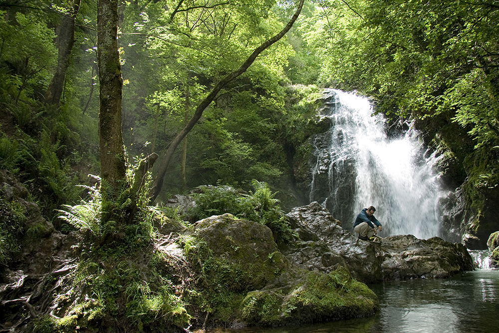
Ruta 14 Xorroxin Urjauzia (Cascada)
- Salida: Erratzu
- Distancia: 5,60 km
- Desnivel:125 m
SENDERO CIRCULAR POR EL QUE SE ACCEDE A LA CASCADA DE XORROXIN, EN LA REGATA DE IÑARBEGI, UNO DE LOS MANANTIALES DEL BIDASOA. LA SUAVIDAD DE LÍNEAS Y COLORES DEL PAISAJE DE BAZTAN CONTRASTA CON LA ESPESURA Y HUMEDAD DEL ENTORNO DE LA CASCADA, CUYA ÉPOCA MÁS RECOMENDABLE PARA VISITAR ES A FINALES DE PRIMAVERA.
El inicio se sitúa en el pueblo de Erratzu, de apretado casco urbano. Un estrecho carretil asfaltado conduce entre prados hasta Gorostapolo, agrupación de caseríos que bien merece una visita. Desde la ermita situada a la entrada, un camino empedrado desciende y cruza la regata o arroyo de Iñarbegi para internarse poco a poco en el interior del barranco, donde destacan centenarios castaños trasmochos. Tras cruzar nuevamente el río, un camino a la izquierda se adentra en el cauce que debemos vadear (atención: piedras resbaladizas) para alcanzar la sonora cascada. Todo el entorno cuenta con abundantes musgos, líquenes y helechos reales que delatan la persistente humedad. El regreso se realiza por el mismo camino hasta el puente de Iñarbegi. Por el barrio de Iñarbil, se regresa a Erratzu.
de Interés
Museo Santxotena
El artista Xabier Santxotena ofrece este espacio al aire libre en el que sus obras se mezclan con el verde de la naturaleza del valle de Baztan entre Arizkun y Erratzu. La casa Gorrienea, el hogar de su familia, se ha reconvertido en un museo etnográfico en el que nos sumergimos en las antiguas tradiciones del caserío vasco.
Cómo llegar
Por la carretera N-121A hasta Oronoz y la N-121B pasar Elizondo. Desvío por la NA-2600 hasta Izpegi.
Ruta 15 San Juan Xar
- Salida Igantzi
- Distancia 15,50 km
- Desnivel 515 m
ITINERARIO BALIZADO COMO SENDERO LOCAL, SE PROPONE COMO SENDERO DE TREKING POR SU LONGITUD Y SE ACONSEJA CONCERTAR TRANSPORTE DE REGRESO (TAXI). SENDERO LINEAL QUE UNE LOS PUEBLOS DE BERA/VERA DE BIDASOA, LESAKA, IGANTZI Y ARANTZA CON SAN JUAN XAR, RESERVA NATURAL QUE ALBERGA EL ÚNICO BOSQUE NATURAL DE CARPES DE LA PENÍNSULA. LA CREENCIA POPULAR CONCEDE PODERES CURATIVOS AL AGUA QUE ALLÍ MANA, AL PIE DE UNA GRUTA.
El inicio se sitúa en Bera/Vera de Bidasoa, junto al puente de San Miguel (peatonal) y asciende por el GR-11 hasta los caseríos de Alkaiaga. Tras un tramo llano que recorría un antiguo ferrocarril minero, el sendero remonta y cruza un arroyo para ascender por camino empedrado hasta una loma y varios caseríos desde donde se divisa Lesaka, a donde descendemos por empinado tramo empedrado. Cruzamos el casco medieval de Lesaka junto a la altiva casa-torre de Zabaleta y, saliendo por la carretera a Igantzi, nos desviamos a la derecha por la orilla del río, ascendiendo con empinados tramos hasta llegar a Igantzi, situada en una elevada y fértil vega. Desde las piscinas municipales descendemos hasta el fondo del barranco de Latsa o Arrata por donde, alternando el camino y la carretera a Arantza, llegaremos al arco de piedra que indica la entrada a San Juan Xar. Un sendero cruza el lugar y, pasado el vetusto caserío Aranibar, se inicia el ascenso por camino empedrado hasta Arantza, final del recorrido.
de Interés
Baile Makildantza de Bera/Vera de Bidasoa
Lo que antaño era una manera de resolver las pugnas locales, es hoy por hoy un colorido espectáculo de danza ceremonial. El dantzari baila con un makil en la segunda parte de la pieza, después de que los pies se preparan para la lucha con unos ejercitantes movimientos (Eskasak). Cada una de las partes va precedida de una pieza musical denominada deia (llamada).
Cómo llegar
Por la carretera N-121A hasta Bera/Vera de Bidasoa y, desde el cruce de Berrizaun, por la NA-4020 hasta Igantzi y Arantza
Ruta 16 Iturburua-Bertiz
- Salida Oieregi
- Distancia 6,50 km
- Desnivel 180 m
SENDERO CIRCULAR POR EL PARQUE NATURAL DEL SEÑORÍO DE BERTIZ HASTA EL NACEDERO “ITURBURUA” EN EUSKERA) DE UN PEQUEÑO ARROYO. EL TRAZADO, CUBIERTO EN SU TOTALIDAD POR BOSQUES DE ROBLE Y HAYA, OFRECE UN INTERESANTE TRAMO DE BOSQUE-GALERÍA EN TORNO A LA REGATA DE SUSPIRU.
Itinerario señalizado, pero sin balizaje ni numeración de sendero local. Iniciamos el recorrido en Oieregi, en el área de visitantes del Parque Natural del Señorío de Bertiz por un amplio y llano camino hasta llegar junto a un horno de cal y la reproducción de una carbonera, que atestiguan otra forma de explotación del bosque. Ascendemos a la izquierda por un sendero empinado al principio. Tras un tramo llano y sinuoso, donde podemos disfrutar del bosque en su plenitud, se toma un desvío a la derecha, que desciende a la fuente de Iturburua y a la regata de Suspiru donde, ante la gran humedad del suelo, las hayas y los robles dejan paso a alisos, fresnos y helechos reales que dominan el bosque-galería. Tras cruzarla, alcanzamos un ancho camino que conduce a la pista inicial y señala el comienzo del recorrido. La excursión se puede completar con la visita al Centro de Interpretación y al Jardín Botánico del Parque Natural del Señorío de Bertiz, hoy patrimonio natural de Navarra.
de Interés
Parque de Bertiz
El palacio y sus jardines pertenecieron a la Casa de Bertiz desde el siglo XIV hasta 1898, cuando este señorío fue adquirido por Pedro Ciga Mayo, quien completó la colección botánica con especies de todo el mundo y en el año 1949 lo donó a la Excma. Diputación Foral de Navarra con la condición de que se conservara sin variar sus características. En 1984 el Gobierno de Navarra lo declara Parque Natural.
Cómo llegar
Carretera N-121A a Irún hasta Oronoz, pasando por Belate. Entrada al Parque Natural a mano derecha, a pie de carretera.
Ruta 17 Ioaldunen Bidea
- Salida: Zubieta / Ituren
- Distancia 5,00 km
- Desnivel: 100 m
SENDERO LINEAL QUE UNE LOS PUEBLOS DE ITUREN Y ZUBIETA, ESCENARIOS DEL RITUAL CARNAVALESCO DONDE COBRAN PROTAGONISMO LOS “IOALDUNAK” (PORTADORES DE CENCERROS). EL RECORRIDO PERMITE, ADEMÁS, LA OBSERVACIÓN DEL MODO DE VIDA DEL CASERÍO, UNIDAD ORGANIZADORA DEL ESPACIO EN LA NAVARRA ATLÁNTICA.
El sendero se inicia en la plaza de Ituren, junto al magnífico edificio del herriko estatua (ayuntamiento, posada, escuela y centro social). Carretil asfaltado hasta Latsaga, desde donde un camino empedrado cruza el río Ezkurra por un uente de piedra, escenario de leyendas de lamiak (sirenas de río, en la mitología vasca). Así se alcanza el pueblo de Aurtitz, al pie del monte Mendaur. Salimos de Aurtitz por la carretera a Zubieta, para desviarnos a la izquierda y cruzar de nuevo el río Ezkurra. Tras un tramo a media ladera entre caseríos y gran variedad de árboles frutales y maderables, se alcanza el pueblo de Zubieta, de apretado caserío y rodeado de campos de maiz. El regreso se puede hacer desde Aurtitz a Ituren por la iglesia de San Martín, situada en su promontorio. Acabado el recorrido, se recomienda la visita al Molino Ecomuseo de Zubieta.
de Interés
Los ioaldunak
Los ioaldunak desfilan en dos hileras, con movimientos rítmicos y acompasados, logrando hacer sonar sus cencerros al unísono. El desfile adquiere un aspecto ritual ligado íntimamente a la naturaleza. Uno de los dos ioaldun de la primera fila hace sonar intermitentemente un cuerno y lanza unos gritos que marcan, por decirlo así, el ritmo del desfile.
Cómo llegar
Por la carretera N-121A hacia Irun, desviarse a Doneztebe/Santesteban y, por la NA-170, se llega a Ituren y a Zubieta.
Ruta 18 Bosque de Leurtza
- Salida Urrotz
- Distancia 9,00 km
- Desnivel 400 m
SENDERO CIRCULAR POR LA CUENCA DEL ARROYO DE LEURTZA, DECLARADA ÁREA NATURAL RECREATIVA POR LA CALIDAD PAISAJÍSTICA DE SUS LADERAS CUBIERTAS DE GRANDES HAYEDOS EN CONTRASTE CON LA LÁMINA DE AGUA QUE CUBRE LOS DOS PEQUEÑOS EMBALSES. HÁBITAT EXCELENTE DE LA RANA BERMEJA.
El sendero se inicia en el área recreativa de Leurtza, situada al final del carretil asfaltado de acceso y junto a la caseta de información y guarda (temporada primavera-otoño). Tras cruzar el dique del embalse superior, remontamos por un camino con tramos calzados hasta alcanzar el collado de Zumardena, junto a un mojón de 1781 y próximo a la cruz de Erlain. Paso del GR-12 (“Senda de Euskal Herria”, por la divisoria cantábrico- mediterránea). Siguiendo el GR en dirección Belate se puede visitar el dolmen de Pittortzar y, de nuevo en Zumardena, continuar por él en tramo lano hasta el collado de Uztakorta (zona muy frecuentada en octubre por cazadores de paloma). De Uztakorta ladeamos el monte Soratxipi por su cara este por pista y una senda carbonera hasta alcanzar el collado de Ezkalarre, donde camino desciende hasta el hayedo y regresa al punto de partida. Este recorrido se puede completar con el Sendero Local S.L. NA-7, más corto, de sólo 3,5 km y que rodea los dos embalses.
de Interés
Embalses de Leurtza
Pese a su reducido tamaño, son un pequeño paraíso donde los paisajes no sólo ofrecen su interés en el recorrido, sino también en la llegada hasta el inicio por la carretera que asciende desde Urrotz, municipio que, junto a Beintza- abaien, posee la titularidad de Área Natural Recreativa. Ambos pueblos se enclavan en la montaña, rodeados de un paisaje siempre verde y húmedo.
Cómo llegar
N-121A hacia Irún, desviarse a Doneztebe/Santesteban y, por la NA-4040 hasta Urrotz. Carretil asfaltado de 5 km asciende hasta los embalses de Leurtza.