


 Fotografía cedida por Turismo de Fitero
Route 46 Atalaya de Peralta
- Departure: Peralta
- Distance: 6,40 km
- Unevenness: 130 m
CIRCULAR TRAIL THROUGH THE SURROUNDINGS OF PERALTA THAT, AFTER A BRIEF SECTION TO THE SHORES OF THE ARGA, GOES UP THROUGH THE VALLACUERA BARRANCO TO FINALLY ASCEND TO A STRATEGIC CORDAL, ENCLAVE OF THE OLD MEDIEVAL CASTLE
The trail begins in Peralta, next to the bridge over the Arga river and a park-green area. After almost a kilometer along a section close to the Arga river, we turn left to gently ascend the Barranco de Vallacuera track, until a detour to the left to cross the ravine and go up the mountain through an old path with a steep slope, until an area of pine forests is reached. By smoother route the path reaches the site of the old medieval castle of the Atalaya, in an area of gypsum outcrops, and which is accessed by a beautiful path and original entrance arch. The place offers magnificent panoramic views. Some stairs and a narrow path descend to the visible urban area, passing through the ruins of the hermitage of Santa Lucía and, in the narrow streets of the town, through the old parish of San Juan Evangelista.
of interest
La Atalaya
No one knows exactly how old the Watchtower is. It was probably inhabited in pre-Roman times. What is known with certainty is that it was snatched from the Moors by Sancho Garcés in the 10th century. Later, King García the Restorer granted the cantons the right to repopulate, but they preferred to go down to live closer to the plain.
How to get
A-15 towards Zaragoza, exit Marcilla. Follow NA-128 until Peralta
Route 47 Desolado de Rada
- Departure: Caparroso
- Distance: 5,30 km
- Unevenness: 120 m
CIRCULAR PATHWAY BY WHICH THE REMAINS OF THE FORTIFIED WATCHTOWER OF RADA ARE REACHED, WHICH TRANSFERS US TO A DEFENSIVE PAST. FROM THERE A LANDSCAPE OF CONTRASTS BETWEEN THE ARIDNESS OF THE BARDENAS REALES AND THE VEGA DEL RÍO ARAGÓN IS DOMINATED
The path begins leaving the town of Caparroso towards Mélida, in a pine forest, in the first section it crosses the Cañada Real de Tauste to Urbasa-Andía and runs between pine trees to get out to clear terrain and between fields of crops it reaches the hill and ruins of the fortification of Rada. From this desolate area, there are wide and contrasted panoramic views, among which the desert landscapes of the Bardenas stand out, the fertile plain of Aragon and the beautiful silhouette of the Monastery of Oliva (see column on the side). For the return, a short section is descended along the road and after the Corral de Villar, it deviates to the right, along a track between agricultural lands until crossing a water conduction channel and merging with the Cañada Real de Tauste to Urbasa-Andía, to leave it after a few meters, going left through a pine forest that leads us to the starting point, in the town of Caparroso.
of interest
Belleza cisterciense
The Monastery of La Oliva is one of the best examples of Cistercian architecture in Spain. King García Ramírez founded it in 1143, and it experienced its maximum splendor in the 12th and 13th centuries, when it had a large number of possessions. After the War of Independence it was looted, although in the 20th century the onastic life was resumed. Its beautiful 14th century Gothic cloister and the Chapter House are two of its main attractions.
How to get
AP-15 motorway towards Tudela, exit Caparroso. Continue to the town (NA-128). Exit on the NA-5500, towards Mélida
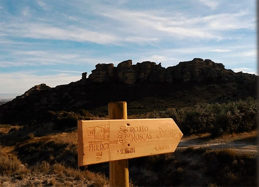
Route 48 Circuito de Roscas
- Departure: Fitero
- Distance: 8,20 km
- Unevenness: 120 m
TRIANGULAR AND GREAT ATTRACTIVE TRAIL PATH THROUGH THE VEGA OF THE ALHAMA RIVER AND AT THE FOOT OF THE SURPRISING MACIZO DE ROSCAS, WHICH IS ASCENDED IN THE MIDDLE OF A LANDSCAPE DOMINATED BY MEDITERRANEAN VEGETATION.
The bridge that crosses the Alhama river is the starting point of the trail, which follows the Valverde road until it reaches a path on the right that goes into irrigated fields. After the orchards we pass near the Cueva de la Mora, and when we turn left we begin a gentle ascent through clear terrain. We pass a cabin on the left with beautiful views of the ruins of the castle of Tudején and Las Roscas. This massif owes its original appearance to the erosion of sandstones, clays and conglomerates. Some of its promontories are home to the breeding place of birds of prey. We continue the route without leaving the main track up to the hill located at an altitude of 555 m, and here the descent begins until a crossroads of tracks. At this point we turn left and continue along the agricultural track between cultivated fields until we cross the Barranco de los Blancares bridge and merge with the Valverde (Soria) road, where we continue to the left in the direction of Fitero until we reach the starting point. .
of interest
The Fitero Monastery
The Fitero Monastery can boast of being the first Cistercian monastery of the peninsula since its foundation dates from 1140, although it is true that the current buildings date from the period between 1185 and 1247. The abbey church and the conventual dependencies stand out. In addition, the paintings, altarpieces and images that it keeps inside are admirable.
How to get
N-121 and N-113 to Cintruénigo. Turn on NA-160 to Fitero. Gas station and NA-6991 towards Valverde. After 2.4 km take the path to the right.
Route 49 Lor Lagoon
- Departure: Barillas
- Distance: 5,20 km
- Unevenness: 30 m
BARILLAS IS THE DEPARTURE POINT OF THIS CIRCULAR TRAIL THAT REACHES LAGOON DE LOR, A PLACE WHERE A VARIED POPULATION OF WATER BIRDS CAN BE OBSERVED. AFTER SURROUNDING THE LAGOON, THE PATH RE GRESA BY AGRICULTURAL ROADS BETWEEN CULTIVATED FIELDS AND CENTENARY OLIVE TREES.
The beginning of the trail runs along an agricultural track of vineyards and olive trees, in ‘La Plana’. When we cross the road from Cascante to Ablitas we reach the shore of the lagoon. From this moment on, the route along an elevated track borders this raft where, depending on the time of year, you can see species such as the coot, the great crested grebe, the gray heron, the red duck, the European porrón, etc. . It is advisable to remain silent and do not get out of the way so as not to scare these birds away. When we arrive at the construction that regulates the outlet of the water from the lagoon, we can appreciate the wonderful view of the Queiles valley: the town of Ablitas, with its castle and church in the highest part, and Barillas. The route continues through an area of aquatic plants. Looking at the water, you can see on the left the town of Ablitas, with its castle and church in the highest part; Opposite is Barillas, and to the right the basilica of Nuestra Señora del Romero. Further on you can see an area of aquatic plants, similar to a pond in a Japanese garden. To return, we cross the road again and through the cultivated fields we arrive at Barillas
of interest
Tulebras Monastery
Founded around 1149 in Tudela and permanently transferred to the banks of the Queiles River in 1157, this monastery claims to be the first Cistercian female monastery in Spain. Since its foundation, monastic life has been maintained in this Romanesque and Renaissance style monastery. The church, the abbey palace and the cloister stand out. In addition, the museum contains various pieces of jewelry, sculpture and painting.
How to get
On the AP-15 motorway to Tudela and continue on the N-121 C until the Barillas junction, on the NA-3040
Route 50 Cabezo del Fraile
- Departure: Bardenas Reales
- Distance: 4,60 km
- Unevenness: 200 m
ASCENT TO THE CABEZO DEL FRAILE, IN THE EXTREME SOUTH OF LAS BARDENAS, WITH SECTIONS OF TRAIL WITH SPECTACULAR PANORAMIC VIEW OF DESERT LOCATIONS. ABSENCE OF DRINKING WATER.
The route begins at the esplanade of the corral de Bea, an appropriate place to park. We head west, skirting the cultivated fields and always following the silhouette of the Fraile (565 m) with our eyes. In this first phase the road is not well defined, although there are abundant cattle trails. After crossing ravines and some hills, we cross an old track that ascends to some large abandoned fields. You continue to climb the increasingly well-defined path, until you reach a rocky area that you have to skirt to reach the summit. Here there are few vestiges of what was a border castle of the Kingdom of Navarra, which Sancho El Fuerte ordered to be built in the 13th century to defend the border between Navarra and Aragon and fight the bandits. Legend has it that in these ruins there is a cave of a Moor, which Bécquer alludes to in one of his poems. The top has an impressive view.
of interest
La reserva negra
On the southern slopes of the Plana de la Negra lies the natural reserve of ‘Falls de la Negra’, the second largest in Navarra. In this peaceful place the crops are interspersed between the bushes, the wooded areas and the ravines. Desert vegetation predominates with specimens of kermes oak, juniper or rosemary, while in the fauna section there is an abundance of wild boar, wild cat or short-toed eagle.
How to get
AP-15 to Tudela and along the NA-126 towards Tauste until km 22, with a detour to the left along the track for 4.5 km to Corral de Bea