
 Fotografía cedida por Gobierno de Navarra
LA CIUDADELA
Localidad: Pamplona
Dirección: Avenida Avda. del Ejército
Zona: La Cuenca de Pamplona
La Ciudadela, referencia urbanística principal de Pamplona, está considerada como el mejor ejemplo de arquitectura militar del Renacimiento español y uno de los más destacados conjuntos defensivos ideados en Europa. Junto con la Vuelta del Castillo, zona verde que la circunda, constituyen el gran pulmón verde de la ciudad, con sus 280.000 metros cuadrados de extensión; así la práctica de footing y otros deportes es habitual a cualquier hora del día.
La Ciudadela nació para vigilar la ciudad del enemigo, a instancias del rey Felipe II, quien la mandó construir en 1571 con el fin de hacer frente a las constantes incursiones del ejército francés. Su estructura original tenía forma de pentágono regular con cinco baluartes en los ángulos, pero la construcción del Primer Ensanche de la ciudad obligó al derribo de dos de ellos.
En su interior, otras fortificaciones y edificios menores se destinan hoy en día a lugares públicos para el ocio y la cultura. Adéntrese en esta fortaleza por la Avenida del Ejército o a través de la Vuelta del Castillo. Y hágalo a pie, porque esta fantástica incursión no acepta otro tipo de transporte.
El ingeniero militar italiano Giacomo Pelearo, “el Fratín”, fue el artífice de este sofisticado sistema defensivo, de moda en la época y similar al existente ya por aquel entonces en la ciudad belga de Amberes. En el siglo XVIII el recinto se rodeó con un sistema de contraguardias, caminos cubiertos, medias lunas y escarpas. Llegó a convertirse en cárcel, recibiendo entre sus rejas a personajes ilustres de la talla del ministro Urquijo o el conde de Floridablanca.
Sólo una vez en su historia fue tomada esta fortificación, en 1808, y ni siquiera fue necesario que el ejército francés disparara un solo tiro. Aprovechando una gran nevada, el enemigo acertó a tomar la Ciudadela ante la confusión del lanzamiento de bolas de nieve entre ambos bandos.
Pero dejemos el pasado. En 1964 el Ejército entregó la Ciudadela al Ayuntamiento de Pamplona, quien se encargó de su remodelación para darle un uso del que diariamente disfrutan miles de vecinos y visitantes. Todas las noches de San Fermín, las murallas de la Ciudadela son testigos mudos del lanzamiento de fuegos artificiales, en el acto más multitudinario de estas fiestas mundialmente famosas.
Para acceder al recinto, hay cinco puertas. Las más transitadas son la Puerta del Socorro, a la que se accede por la Vuelta del Castillo, atravesando un puente sobre los fosos que en su día fue levadizo, y la entrada principal, en la Avenida del Ejército, en la que destaca su sobriedad renacentista. En esta última y tras atravesar la muralla, se llega al Cuerpo de Guardia, un edificio que hoy se usa como oficinas municipales.
Pabellones, fosos, baluartes, rebellines y glacis salpican el recinto amurallado dentro de un agradable parque público donde no faltan senderos, una plazoleta central con fuente, una treintena de diferentes especies arbóreas, diversas esculturas (Jorge Oteiza, Néstor Basterretxea, Vicente Larrea, Alberto Eslava…) y una zona de ocio infantil. Esta fortaleza está abierta sólo durante el día y en ella está prohibida la circulación de todo tipo de vehículos, incluidas las bicicletas.
Además, el parque combina su uso recreativo con el de recinto cultural, ya que la conservación y remodelación de antiguos edificios militares ha permitido su uso actual como sede de exposiciones y muestras culturales, sobre todo de arte contemporáneo. Hablamos del Polvorín y el Pabellón de Mixtos, los más antiguos, y la Sala de Armas, de finales del XVIII, junto con el Horno.
El recinto se completa con un frontón de uso público y gratuito en la zona de los fosos, así como dos semblanzas de la Rosa de los Vientos.
El Parque de la Ciudadela está abierto todos los días. De lunes a sábado de 7:30 a 21.30. Domingos y festivos, de 9:00 a 21:30 horas. Las exposiciones abren los días laborales por la tarde; el resto, por la mañana. El acceso a los fosos está libre de horarios, pero se recomienda no transitarlo en horas nocturnas.
PARQUE FLUVIAL DEL ARGA
Localidad: Pamplona
Dirección: Paseo por el río Arga
Zona: La Cuenca de Pamplona
Pamplona tiene río: el Arga. Y un largo y variopinto paseo natural de recreo, su Parque Fluvial, que dibuja meandros en un recorrido de cerca de 12 kilómetros. Su millón de metros cuadrados lo convierten en el primer y gran pulmón verde de la ciudad.
Una sucesión de puentes históricos, presas, molinos, pasarelas, jardines, parques, embarcaderos, merenderos, puntos de pesca, granjas, huertas, cercados con caballos y vacas, fuentes, un frontón y hasta un Museo de Educación Medioambiental recorren este bello y ameno paraje, simbiosis de agua y vegetación.
En ocasiones, el río se aproxima a la ciudad o se esconde de ella; conjuga zonas de actividad deportiva que frecuentan pescadores, piragüistas o ciclistas con idílicos oasis de paz; discurre ancho y pausado o se alborota en sus presas y estrechamientos…
El Arga circunda Pamplona y la atraviesa. Si se anima a seguir sus pasos, tiene mucho por descubrir.
El Parque Fluvial del Arga es un largo paseo que discurre a orillas del río Arga. Se adentra en la ciudad de Pamplona por las huertas de la Magdalena, cuyas verduras gozan de gran fama por su calidad y sabor, cruza el barrio de la Rochapea y, tras aproximarse al casco urbano de la ciudad, se aleja por el barrio de San Jorge. También recorre las orillas de muchas localidades de la Cuenca de Pamplona como Burlada, Villava, Arre, Barañáin o Zizur Mayor.
Esta bella zona verde es fruto de una década, la de los 90, dedicada a su recuperación medioambiental, gracias también al apoyo económico de la Comunidad Europea. Este proyecto ha permitido la recuperación del cauce y las orilla del río, mediante su desbroce y saneamiento, y la creación de un largo paseo natural ininterrumpido para poder realizar a pie o en bicicleta, jalonado de nuevos parques, pasarelas, embarcaderos y viejos molinos hoy renovados. Fresnos, sauces, alisos, tilos o endrinos forman la flora autóctona, que convive con una variada fauna de tortugas, peces y patos, entre otros.
El recorrido en Pamplona, siguiendo la dirección del río de este a oeste, se divide en cuatro tramos: Magdalena, Aranzadi, Rochapea y San Jorge. Cada uno de ellos recoge singulares atractivos abiertos al deportista, al aficionado a la pesca, al paseante tranquilo, al juego en familia, o a la pareja de enamorados…
En el meandro de la Magdalena abundan las huertas y granjas. En ella existe una bonita presa donde se encuentra el Molino de Caparroso y la pasarela de la Magdalena, que conduce al Parque de Tejería. Al final de este tramo, el paseante descubrirá el primero de los nueve puentes del recorrido, también llamado de la Magdalena, un bello puente medieval que atraviesan los peregrinos en su camino hacia Santiago de Compostela.
El tramo de Aranzadi se aleja de las murallas y discurre a partir del Molino de Ciganda, muy retratado por los pintores locales. En la calle Errotazar se encuentra el Museo de Educación Ambiental y, poco más adelante, el Puente de San Pedro, el más antiguo de la ciudad, cuyo origen podría remontarse a la época romana.
El tramo de la Rochapea se acerca de nuevo a los pies del casco antiguo, zona de gran actividad comercial y de ocio, con las torres de la Catedral al fondo. Varios son los puentes por los que atraviesa el río, algunos de factura moderna,: el del Vergel, la Rochapea o de Curtidores, el de Oblatas, Santa Engracia y Cuatro Vientos.
Ya en el tramo de San Jorge, el paseo deja atrás un frontón, una fuente, una presa, un puente y un molino. Dos parques, el de San Jorge y Biurdana, flanquean el cauce. A lo lejos, queda el barrio de San Juan, y un poco más allá, el Puente de Miluce anuncia el final de la ciudad. A partir de ahí, el Arga se adentra en un paisaje arbóreo, tranquilo y silencioso. Pamplona ya se ha quedado atrás.
PARQUE DE LA MEDIA LUNA
Localidad: Pamplona
Dirección: Paraje Parque de la Media Luna
Zona: La Cuenca de Pamplona
Bordeando el centro de la ciudad, en el Segundo Ensanche, y en un extremo de las murallas, el Parque de la Media Luna, uno de los más bellos y antiguos de Pamplona, debe su nombre a su diseño en forma de luna menguante.
Lugar bucólico y de marcado estilo romántico, este parque dispone de excelentes vistas gracias a un privilegiado y largo mirador sobre el río Arga. Cuenta con un estanque con peces, pista de patinaje y mucho arbolado con diferentes especies, entre las que destaca una bellísima sequoya gigante. Punto de conciertos, especialmente los del ciclo de jazz en junio, uno de sus muchos y variopintos jardines alberga el monumento al violinista pamplonés Pablo Sarasate.
En el corazón de este verde recinto, un coqueto café con amplia terraza en su exterior cobra especial animación durante las calurosas tardes y noches del verano.
El Parque de la Media Luna fue construido en 1935 por Víctor Eúsa, sin duda uno de los arquitectos navarros de mayor relieve del siglo XX. Con una extensión de 67.000 metros cuadrados, se ubica en uno de los extremos del antiguo recinto amurallado de la ciudad, entre el Baluarte de San Bartolomé y la avenida Baja Navarra, que conecta Pamplona con la salida hacia Francia por Irún.
A pesar de encontrarse en el mismo centro de la ciudad, el diseño del parque y su amplitud lo convierten en un auténtico oasis para la calma. Quizás el perfil más hermoso de la Catedral, inmortalizado en muchos de los lienzos de pintores navarros, se pueda observar desde el largo mirador que limita este parque y que permite disfrutar pausadamente de una agradable panorámica de esta singular parte de la ciudad bordeada por el río Arga. Allá, abajo, se pueden ver el puente medieval de la Magadalena y las huertas del mismo nombre, el paseo del Arga e incluso caballos y ganado.
Mire en sentido contrario y, ya adentrándose en sus jardines, podrá descubrir todo un juego de variados elementos al más puro estilo romántico: pérgolas, albercas, escalares, fuentes, setos, pequeñas esculturas, árboles de gran porte, surtidores y bancos salpican el entramado verde del recinto.
La Media Luna reúne una original selección de plantas y de hasta 43 especies arbóreas, entre las que se erige, con cierta arrogancia, una sequoya gigante, que, a pesar de todo y dicho sea de paso, no es la mayor de Pamplona. Le anteceden otras dos: la del Palacio de Navarra y la del antiguo Laboratorio Agrícola, en el Casco Antiguo, todas ellas declaradas monumento natural.
Otro punto emblemático que sin duda atraerá la atención del visitante es el monumento al insigne violinista pamplonés Pablo Sarasate, levantado en 1959, en una estancia circular rodeada de bancos. Muy cerca de allí, un coqueto bar con terraza, de concesión municipal, abierto todos los días desde las 11 de la mañana, es un buen lugar para un tentempié. El local organiza, además, fiestas de carácter privado.
No es extraño que la música llegue hasta nuestros oídos, gracias a los conciertos de diversos estilos que se organizan con cierta asiduidad en este recinto verde. Muy recomendable el ciclo de jazz que tiene lugar durante las tardes-noche de comienzos del verano.
Ya al final del Parque de la Media Luna, cuando se funde ya con la avenida de la Baja Navarra, se encontrará con el monumento de Sancho el Mayor, Rey de Pamplona. A su lado, un bajorrelieve recuerda la figura de Juan Huarte de San Juan, médico y filósofo navarro del siglo XVII. Llegamos así a un elegante palacete construido en 1955, conocido popularmente como el Chalet de Izu, Centro Navarro de Encuentros Profesionales y sede de varios colegios oficiales, que alberga en su interior, en medio de un refinado lujo, un restaurante abierto también al público.
JARDINES DE LA TACONERA
Localidad: Pamplona
Dirección: Jardines Calle del Bosquecillo
Zona: La Cuenca de Pamplona
Los Jardines de la Taconera constituyen el parque más antiguo, hermoso y emblemático de Pamplona. Con sus 90.000 metros cuadrados de superficie, se asienta en torno a las murallas, muy cerca del Casco Antiguo, dentro de un marcado estilo romántico y versallesco.
Su estructura, jalonada de especies arbóreas y florales con elementos escultóricos muy diversos, permite diferentes itinerarios al visitante. Pero si algo caracteriza a este paradisíaco lugar es el pequeño zoo que alberga en sus fosos y en el que conviven ciervos, patos, faisanes, cisnes, pavos reales… en estado de semilibertad.
Recorrer la Taconera es descubrir portales a modo de arcos de triunfo, el monumento al ilustre tenor roncalés Julián Gayarre, diversas esculturas entre la que destaca la querida y popular Mariblanca, o los arcos ojivales de Teobaldo II. El Café Vienés es lugar habitual de encuentro de creadores y estudiantes de la ciudad.
Ya en los planos de 1719 de la ciudad, aparece la Taconera como espacio verde. El parque está siempre abierto al público y su acceso más señorial, el Portal de San Nicolás (1666), recreación barroca de un arco del triunfo, se encuentra en la calle del Bosquecillo. También se puede acceder a través del Portal de La Taconera, junto a los jardines de Antoniutti.
La Taconera cautiva en cuestión de minutos. Basta con asomarse al mirador que se abre desde la calle Navas de Tolosa para contemplar un mini zoo situado en unos fosos limitados por un recinto amurallado. Ciervos, conejos, gamos, patos, faisanes, cisnes, cabras, pavos reales y otros anátidas, en total una treintena de ejemplares, conviven en un espacio que por Navidad se adorna con figuras de un Belén de tamaño natural. Al otro extremo del foso, en su lado norte, otro mirador le permitirá contemplar la fauna, a través de cinco bellos arcos ojivales.
Posee una vegetación muy variada con árboles antiguos y exóticos. El parque está rodeado por parte de las murallas que circundaban la ciudad. Además conserva elementos ornamentales que le permitirán ir haciendo pequeños altos en el camino: el Monumento a Gayarre, en el paseo central, en honor al tenor roncalés (1844-1890) de fama mundial. Muy cerca de allí, otro parterre ensalza la figura del músico burladés Hilarión Eslava (1807-1878). Escondida entre los árboles, no olvide saludar a la Mariblanca, una escultura de finales del XVIII, que recoge una de las imágenes más populares y queridas de la ciudad y que representa una alegoría de la Abundancia o Beneficiencia.
En su lado norte, el parque dispone de un mirador con una buena panorámica de algunos barrios de Pamplona, y del antiguo Portal de Santa Engracia, hoy llamado Portal Nuevo, otro punto de entrada o salida al recinto.
Los niños cuentan también con un parque de ocio. Muy cerca hay una bonita fuente de agua potable y no faltan los servicios de hostelería. El Café Vienes, antaño caseta de alquiler de bicicletas, es un coqueto recinto geométrico a la sombra de un retorcido ejemplar de Sófora Japónica, donde se puede degustar una amplia carta de cafés, tés y sabrosas tartas.
El parque Larraina es la prolongación natural del de la Taconera y tiene excelentes vistas sobre el río Arga. Contiguo a él está el de Antoniutti, un parque muy arbolado y fresco que cuenta con una pista de patinaje, un parque infantil y una pista de skate.
PARQUE YAMAGUCHI
Localidad: Pamplona
Dirección: Jardines Calle La Rioja (Cerca de la Clínica Universitaria)
Zona: La Cuenca de Pamplona
Pamplona está salpicada de hermosas manchas verdes, pero ninguna tan singular como el Parque de Yamaguchi: 85.000 metros cuadrados en una de las zonas más modernas de la ciudad.
De estilo oriental, fue diseñado en 1997 por paisajistas nipones, por lo que contiene todos los elementos propios de un jardín importado de la cultura del Sol Naciente, con todos sus mimos, refinamientos y exquisiteces. El parque es símbolo del hermanamiento de las ciudades de Pamplona y Yamaguchi, muy cerca de Hiroshima, que tuvo lugar en 1980 como recuerdo a la evangelización de San Francisco Javier, patrón de Navarra, a aquel país durante el siglo XVI.
Plantas y especies arbóreas, algunas autóctonas, conviven con elementos ornamentales como la suhama (playa), azumaya (caseta sobre el estanque), yatsubashi e ishibasi (puentes), taki (cascada) o el géiser del lago, un chorro de agua que alcanza los veinte metros de altura. Pasee para divertimento de sus sentidos por este homenaje nipón a las cuatro estaciones.
El Parque de Yamaguchi, situado muy cerca de la zona hospitalaria, es una zona verde atípica y cargada de singularidades. El visitante se trasladará inevitablemente en su recorrido a Oriente y atisbará a un extremo el Planetario, el mayor del mundo por su bóveda celeste, donde a diario se celebran encuentros, exposiciones y proyecciones de divulgación científica para todos los públicos.
A su alrededor, un diseño arquitectónico de vanguardia, obra del arquitecto catalán Oriol Bohigas (1994), con edificios de vivienda en forma de U, fuentes y plazas porticadas que cortejan a la calle La Rioja. Una alta concentración de salas de cine y establecimientos de hostelería al aire libre, que invitan al ocio y la diversión del público en general, son el fiel reflejo de una ciudad que crece a pasos agigantados en calidad de vida y modernidad.
Creado sobre el solar de una antigua fábrica, este jardín japonés tradicional, cuyos orígenes datan del siglo VII, invita a la meditación. Su simbología recoge la celebración de las cuatro estaciones y traslada al visitante a la Ceremonia del Té, una tradición que data del siglo XVI y que hace del jardín un lugar de encuentro espiritual alejado del mundanal ruido.
Es este jardín nipón el que ocupa el corazón del Parque de Yamaguchi. Se extiende a través de 4.000 metros cuadrados de terreno y está formado por un estanque rodeado de un espacio ajardinado, con los elementos propios de la cultura oriental conectados a través de caminos peatonales. Quinientas toneladas de piedra, 400 árboles y 600 plantas hacen el resto.
Empiece su visita por la parte oeste del parque, junto al Planetario. Apóyese en la barandilla, baje sus ojos y mire al frente: sobre el lago, una placa de cerámica sobre unos troncos de madera, obra de la escultora pamplonesa Concha Cilveti, simboliza el hermanamiento y sirve de guía al panorama que se alza ante el observador. Gire la vista a su izquierda.
Ahí esta la suhama o playa de arena y piedra. Al frente, al otro extremo del lago, el yatsubashi, una pasarela o puente de madera que conecta dos pasos peatonales. Siga con su recorrido visual hacia la derecha. Se topará con el ishibasi, un puente de piedra que simboliza los caminos de la vida, y el taki o cascada, cuyo discurrir del agua simboliza la idea de que todo fluye y cambia.
A continuación, la azumaya o caseta de madera construida a modo de palafito sobre el estanque, es, sin duda, lugar privilegiado para observar el jardín en su conjunto. Acérquese hasta allí y entonces lo verá sin necesidad de advertencia alguna: altivo y poderoso, un géiser o chorro de agua de más de veinte metros de altura se alza sobre el eje del estanque, siempre que el viento no esté encolerizado.
OTRAS LOCALIDADES DE NAVARRA
Bosque de Orgi
Localidad: LIZASO (31799)
Dirección: Carretera Entre la carretera de Lizaso y Gerendiain
Zona: Los Pirineos
Figura protegida: Área Natural Recreativa
Teléfonos: 948305300
Orgi es un robledal que se extiende al sur del Valle de la Ultzama, a 25 kilómetros de Pamplona. Se trata de un bosque milenario de ochenta hectáreas, único testigo de los robledales que abundaban en los valles húmedos del norte de Navarra. En Orgi se ha creado un Área Natural Recreativa para que convivan la conservación del bosque y su uso público.
Cuenta con un amplio aparcamiento a la entrada, una zona de merenderos y una caseta de información en la que se inicia la zona de paseos. Los recorridos son totalmente llanos y se pueden realizar a pie e incluso en silla de ruedas. En Orgi disfrutará de un bosque en pleno proceso de regeneración natural, de un sencillo paseo y, en su entorno, de delicias de la gastronomía como la cuajada, los quesos o los licores que allí se elaboran.
A 20 km al norte de Pamplona, entre Gerendiain y Lizaso, se encuentra el bosque de Orgi. Una de sus peculiaridades es la existencia de un tipo de roble que puede vivir en los suelos encharcados de fondo de valle, los Quercus robur; muchos de ellos son centenarios e incluso bicentenarios.
El bosque está organizado en tres zonas: a la de acogida se le denomina Arigartzeta, la de los paseos es Tomaszelaieta y también existe la zona de conservación de Muñagorri, a la que no puede acceder el público por encontrarse en proceso de regeneración natural.
La Zona de Acogida de Arigartzeta es la parte que da acceso al robledal. Dispone de aparcamiento, merenderos, baños y una caseta de información abierta al público que abre diariamente en verano y los fines de semana y festivos el resto del año. Entre semana existe un servicio de visitas guiadas.
La Zona de paseos de Tomaszelaieta ocupa 37,5 hectáreas. Se puede realizar un paseo corto (el Laberinto) de apenas 300 metros; otro de 1.400 (el Camino) que puede ampliarse en otro de 700 (la Senda); los tres están perfectamente señalizados.
“El laberinto” le adentrará en el bosque por un trazado sinuoso que acaba en el “Árbol caído”, un roble gigante derribado antaño por el viento y hoy cubierto por otras plantas.
Si tiene tiempo y curiosidad, siga por el “Camino” y por la estrecha “Senda”. Encontrará rincones acondicionados con bancos de madera, pasarelas e incluso una pequeña caseta para observar aves, por lo que llevar unos prismáticos puede ser de utilidad. La charca salina existe allí como vestigio del mar que ocupó este lugar hace 180 ó 200 millones de años.
En su paseo, descubrirá que los robles americanos y rojos conviven con árboles menores como acebos, arces y olmos, y un rico sotobosque de herbazales, helechos, brezos o enebros. Si camina en silencio, tal vez pueda escuchar el canto de los pájaros, percibir el rápido movimiento de pequeños anfibios o distinguir a algún murciélago.
Ya fuera del bosque, se pueden realizar otros recorridos peatonales más largos como el denominado Orgi, de 8,4 kilómetros, Amati, de 10,5 kilómetros o Gurbil, de 18 kilómetros e ideal para hacerlo en bicicleta.
Orgi es uno de los escenarios naturales en los que tiene lugar Cultur, un ciclo de espectáculos y eventos que se celebra en Navarra todos los veranos, y que en este caso acoge a pequeños grupos musicales que interperetan música clásica en medio del bosque.
En las inmediaciones, resulta muy interesante visitar las localidades de Lizaso o Gerendiain, con bonitos caseríos, acercarse a visitar la casa museo de la miel en Eltso/Gerendiain, al Club de Golf Ulzama o al Lizaso Centro de Golf, donde se puede practicar el “Pitch & Putt”.
Cuevas de Ikaburu
Localidad: Urdazubi/Urdax
Zona: Los Pirineos
Teléfono: 948599241
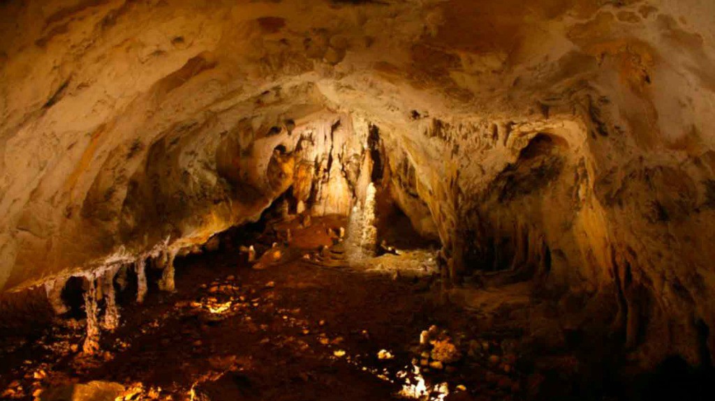
Escondidas bajo los verdes prados de la Navarra cantábrica, en la localidad pierenaica de Urdazubi/Urdax, y a pocos kilómetros de la costa y de la frontera con Francia, se encuentran las Cuevas de Ikaburu, gruta que se originó hace unos 14.000 años gracias a la erosión del río Urtxuma que la atraviesa.
Una visita guiada por sus galerías le descubrirá un universo de estalactitas y estalagmitas, además de traerle evocadores recuerdos de personajes de leyenda, guerrilleros y contrabandistas que las ocuparon en otras épocas.
Las Cuevas de Ikaburu se abren a pocos kilómetros del mar Cantábrico y a escasos minutos de la frontera de Dantxarinea, en el barrio de Leorlas de Urdazubi/Urdax. La gruta fue descubierta por un pastor en 1808, pero se originó mucho tiempo atrás, hace unos 14.000 años, gracias a las aguas del río Urtxuma que perforaron la roca calcárea y dieron lugar a las bellas formaciones de estalagmitas y estalactitas que hoy podemos contemplar.
Los restos de sílex hallados en ellas revelan que fueron habitadas por el hombre prehistórico; muchos siglos después, sirvieron de escondite para contrabandistas o de refugio durante la Guerra de la Independencia y las contiendas carlistas. Y las leyendas locales cuentan que son morada de las lamias, seres mitológicos mitad pez y mitad mujer.
Si desea conocer las cuevas, durante unos 30 minutos, podrá seguir un recorrido acondicionado con escaleras e iluminación, en el que descubrirá las infinitas formas que el agua ha perfilado en su goteo de siglos en el “Salón de Recepciones”, la “Sala de los Tres Reyes” o la “Sala de las Columnas”. Repare en los brillos que descubren la presencia de magnesio en las rocas y déjese envolver por el sonido del río Urtxuma que fluye por sus galerías.
Un cómodo sendero, de escaso desnivel, une las Cuevas de Ikaburu con las de Zugarramurdi y Sara, éstas últimas al otro lado de la frontera. El recorrido, que suma entre ida y vuelta 12 km y está señalizado con caballitos pintados, discurre tranquilo entre prados y bosques.
Además de las cuevas, este pequeño municipio de cerca de 376 habitantes alberga el monasterio de San Salvador de Urdax, un cenobio del siglo XII que fue hospital de peregrinos de la ruta baztanesa del Camino de Santiago. Una visita guiada le muestra el claustro de este antiquísimo edificio y le permitirá asistir a una molienda tradicional. Cerca del molino, se ha construido una fuente en honor al escritor Axular, oriundo de la localidad.
Cuevas de Zugarramurdi
Localidad: ZUGARRAMURDI (31710)
Zona: Los Pirineos
Teléfonos: 948599060 – 948599170 – 948599305
En el Pirineo occidental, superado Baztan y a escasa distancia de la frontera está Zugarramurdi, el pueblo de las brujas, donde fantasía y realidad se mezclan para regalar a la imaginación la posibilidad de hacer un apasionante viaje a través del tiempo.
Sus cuevas, que se encuentran próximas al pueblo de Zugarramurdi, se pueden visitar desde las 9:00 horas hasta el anochecer. No contienen estalactitas ni estalagmitas, ni en sus paredes se han descubierto pinturas rupestres; pero conservan un atractivo casí único: hasta el siglo XVII acogieron supuestamente akelarres, reuniones paganas en las que hombres y mujeres (brujas y brujos para la época) escapaban de la cotidianeidad a través de festines desenfrenados, danzas en torno a hogueras y orgías a la luz de la luna.
Además del sendero que las recorre, se pueden realizar hermosos paseos que las unen a las cuevas de Urdazubi/Urdax y Sara.
Zugarramurdi se sitúa en el norte de Navarra, en el lado occidental del Pirineo, casi en plena frontera y coloreado por una inagotable paleta de verdes que contrasta con el blanco de sus caseríos. Un paseo por las calles del pequeño pueblo de Zugarramurdi, de 230 habitantes, servirá de perfecta ambientación antes de dirigirnos a las cuevas. Saliendo del pueblo, a sólo 400 metros, descubrirá un conjunto natural de impresionante belleza: el arroyo Olabidea, que nace en el infierno según asegura su denominación en euskara “Infernuko erreka”, ha excavado un túnel natural de 120 metros de largo con alturas de hasta 12 metros, y dos galerías elevadas.
Al entrar en las cuevas, unas escaleras le bajarán hasta la cavidad principal, amplio tunel natural de más de cien metros que recorre el arroyo llamado “Infernuko erreka”, y en la parte de arriba, se encuentran las galerías de “Sorgin Leze”.
Las cuevas no contienen estalactitas, ni pinturas rupestres, pero sí un atractivo singular gracias a su amplitud y a la leyenda que las envuelve; en ellas resulta fácil imaginar los akelarres -reuniones de carácter pagano protagonizadas por las brujas del lugar- que allí se celebraron. Las leyendas de brujas y brujos, de rituales paganos y de banquetes presididos por el diablo le acompañarán en su paseo por las grutas que reciben el nombre de “Sorgin Leze” (cueva de las brujas) en el lado más abierto del túnel, y de “Akelarre Leze” (cueva del akelarre) en la parte más estrecha.
Imagine los festines de antaño, las danzas alrededor de las hogueras, los rituales vividos o imaginados por una Inquisición que en la Edad Media castigó de manera despiadada a los habitantes de Zugarramurdi. En el año 1610, la Inquisición procesó a 31 vecinos de la zona -la mayoría mujeres- acusados de brujería, cuyos nombres recoge un panel a la entrada de la cueva. Algunos sobrevivieron tras confesar sus culpas y pedir miseridordia, pero 13 murieron al no poder sobrellevar las torturas a las que fueron sometidas en la cárcel de Logroño. Las seis restantes fueron quemadas vivas en la plaza de Logroño ante 30.000 almas.
Una celebración revive anualmente este pasado cada 18 de agosto, último día de las fiestas patronales, en que se celebra el tradicional zikiro jate, una comida popular a la que asisten 800 personas y en la que se sirve cordero asado en estacas.
Existe un sendero de 8 km que une las cuevas de Zugarramurdi con las de Urdazubi/Urdax y Sara (al otro lado de la frontera); el recorrido está señalizado con un caballo pintado de azul y entraña poca dificultad.
Embalse de Alloz
Localidad: Alloz
Dirección: Entre Yerri y Guesálaz
Zona: La Zona Media
¿Le gusta practicar el windsurf o la vela? ¿Le apetece refrescarse en las tranquilas aguas de un embalse? ¿Y pasear por sus alrededores?
Si se encuentra cerca de Estella lo tiene fácil porque a sólo quince minutos de esta ciudad se encuentra el embalse de Alloz, el segundo en importancia de Navarra después de Yesa.
Es un lugar fantástico para disfrutar de los deportes náuticos, bañarse o, simplemente, para relajarse.
A 12 kilómetros de Estella en dirección noreste, entre los municipios de Yerri y Guesálaz, se encuentra el embalse de Alloz, un mar de agua alimentado por el río Salado, rodeado de quejigales, pastizales, matorral y pinos.
Construido en 1930, ocupa una superficie de 930 hectáreas y tiene capacidad para almacenar 84 Hm3 de agua. En primavera y verano, se convierte en un lugar muy apropiado para estrenarse en la vela y en el windsurf, y es punto de concentración de los surfistas cuando en el vecino mar Cantábrico no hay viento, ya que en el embalse de Alloz son muy habituales los vientos de fuerza tres y cuatro apropiados para la práctica de este deporte.
También es lugar elegido por los aficionados a la pesca que suelen acudir a la cola del pantano donde se captura, fundamentalmente, trucha, barbo y carpa.
A orillas de este pantano, en Lerate, está el camping Aritzaleku, desde donde se organizan actividades que tienen como escenario el embalse. Durante el verano, en el pantano se alquilan distintas embarcaciones, como piraguas, tablas de windsurf y pequeñas barcos de vela.
Si no le atraen los deportes náuticos y prefiere pasear, puede hacerlo bordeando el embalse. También puede aprovechar para hacer un recorrido por los valles de Yerri y Guesálaz, salpicados de suaves lomas y pequeños pueblos dedicados a la agricultura y ganadería. El otoño es la mejor época para visitar estos valles, ya que las esparragueras crecidas y los viñedos tiñen el paisaje de diversos colores.
Otra opción es acercarse, a través de una pista, a Iturgoyen para ascender hasta la ermita de la Santísima Trinidad desde donde se obtiene una excelente panorámica. También puede dirigirse a la cercana Estella para descubrir una ciudad desbordante de historia y tesoros artísticos o al monasterio de Iranzu ubicado en medio de un bello entorno natural.
Foz de Arbayún
Localidad: Domeño
Dirección: Paraje Entre Lumbier y el Romanzano
Zona: Los Pirineos
Figura protegida: Reserva Natural y Zona de Especial Protección de las Aves
La Foz de Arbayún, entre Lumbier y el Romanzado, es la más extensa e impresionante de las gargantas navarras. El río Salazar, que fluye por ella, ha tallado la roca dando lugar a una hoz de 5,6 kilómetros de longitud e imponentes paredes verticales que llegan a alcanzar en algunos puntos hasta 300 metros de altura.
En su interior crece variada vegetación y en sus roquedos anida una numerosa colonia de buitres leonados que verá volando si se asoma a Arbayún desde el Mirador de Iso.
Esta inmensa riqueza natural le ha valido a la Foz de Arbayún las denominaciones de Reserva Natural y Zona de Especial Protección de las Aves.
El río Salazar baja del pirineo y al encontrarse con la Sierra de Leire, situada en la Zona Media de la comunidad, la atraviesa dando lugar a la Foz de Arbayún. Esta profunda y estrecha garganta es la reina de las foces de la Comunidad Foral por su extensión -cerca de seis kilómetros de longitud- y por sus impresionantes paredes verticales de hasta 300 metros de altura.
Para admirarla, no hay mejor lugar que el mirador de Iso, un voladizo sobre las aguas del Salazar situado en la carretera NA-178, que va de Lumbier a Ezcároz. Asómese a su privilegiado balcón y déjese envolver por la espectacular belleza y tranquilidad que infunde este rincón natural.
El río describe tres curvas de Norte a Sur y después enfila hacia el Oeste/Suroeste. En el primer tramo, las paredes llegan hasta el cauce, mientras que foz adentro descansan sobre un talud inclinado. La vegetación crece a sus anchas en las profundidades, surgiendo a veces de la misma roca; en las laderas soleadas crece la carrasca, quejigos y enebros, y en las umbrías aparecen hayas, robles, pinos y fresnos. En otoño la foz se viste de mil colores y pasa por todas las tonalidades que van del verde al ocre pasando por explosivos naranjas y rojos.
Si alza la mirada hacia el roquedo seguro que avistará nidos de buitres o de alguna otra rapaz; la colonia de buitres leonados ha crecido tanto en los últimos años que es habitual verlos sobrevolando el lugar.
El interior de Arbayún resulta bastante inaccesible, pero existen paseos que le permitirán obtener excelentes panorámicas. Uno de los más conocidos es la ruta de la canaleta, un sendero señalizado de 3,2 kilómetros que nace de una explanada a 500 metros de la localidad de Usún. El camino recorre el borde de la reserva natural, pasando por la ermita de San Pedro, y su tramo más espectacular discurre por la antigua conducción de agua a Lumbier, una estrecha canaleta que recorre a decenas de metros de altura la pared izquierda. Absténgase si padece de vértigo.
En el Centro de Interpretación de las Foces, ubicado en Lumbier, encontrará datos sobre éste y otros senderos, así como información de la flora, fauna y cultura de la zona. Aprovechando la ocasión, acérquese hasta la vecina Foz de Lumbier, que podrá visitar recorriendo el sencillo paseo que la atraviesa y que discurre por el trazado del ya desaparecido tren Irati, el primer tren eléctrico de España.
Foz de Lumbier
Localidad: Lumbier
Zona: Los Pirineos
Figura protegida: Reserva Natural
Colonias de buitres leonados sobrevolando el acantilado; bravos escarpes donde nidifican las aves; un río de limpias y frescas aguas que talla en las rocas estrechos y caprichosos pasos; los restos de un puente que, según cuenta la leyenda, fue construido con ayuda del diablo; dos túneles que antaño atravesó el Irati, primer tren eléctrico de España.
Vida y paisaje agreste del que podrá disfrutar si se acerca a la foz de Lumbier, una garganta estrecha labrada por el río Irati que descubre un singular paisaje de roquedos escarpados, morada de grandes rapaces. A esta reserva natural se accede desde un aparcamiento cercano.
Senderos señalizados le conducirán por un desfiladero que anuncia las primeras estribaciones del Pirineo oriental navarro.
Desde la cercana localidad de Lumbier, se llega a un aparcamiento situado a escasos metros del acceso a la garganta. La foz de Lumbier es un desfiladero excavado por el río Irati sobre la roca caliza en el extremo occidental de la sierra de Leire, al pie del Pirineo navarro. Es una de las gargantas más espectaculares de Navarra, un paisaje labrado a lo largo de millones de años por la acción del río Irati que, día a día, sigue marcando su huella en este santuario de la naturaleza, reserva natural desde 1987.
La de Lumbier es una hoz estrecha y pequeña, de 1.300 metros de longitud, y de una belleza espectacular. Sus paredes verticales alcanzan en su cota máxima 150 metros de altura, y en sus grietas, roturas y repisas viven grandes rapaces, entre los que abundan los buitres leonados, cuyo vuelo le acompañará en su visita al desfiladero. La foz, que también sirve de refugio para zorros, jabalíes, tejones y alimoches, está poblada de quejigos y coscojas, además de arbustos como tomillo, espliego y ollaga que se cuelan por las grietas, vegetación que se transforma en bosques de álamos, sauces y fresnos a la entrada y salida de la foz.
A diferencia de otras gargantas, la de Lumbier puede ser recorrida a través de un sencillo camino que discurre al pie de los acantilados, a lo largo de 2,6 kilómetros. El trazado fue realizado para el tren Irati, el primer tren eléctrico de España, que comunicó Pamplona con Sangüesa entre 1911 y 1955.
El camino está señalizado, discurre junto al río y atraviesa la roca a través de dos túneles, de 206 y 160 metros de longitud, que no poseen luz artificial. En la parte final del sendero, el camino bordea la roca y llega hasta los restos del Puente del Diablo, construido en el siglo XVI, con un arco elevado 15 metros sobre el río. Destruido por los franceses en 1812, durante la Guerra de la Independencia, debe su nombre a una leyenda según la cual su constructor pidió ayuda al diablo para levantar el puente.
Existe un segundo recorrido de 5,5 kilómetros que parte del mismo sitio. Señalizado con marcas verdes y blancas y postes de madera, el camino rodea la foz por las laderas inmediatas y vuelve por el interior de la garganta, desde donde se llega de nuevo al aparcamiento. Tiene 175 metros de desnivel y permite visitar el entorno.
Para conocer un poco mejor el ecosistema de la zona, puede visitar en Lumbier el Centro de Interpretación de las Foces que, a través de exposiciones, audiovisuales y simulaciones, ayuda a familiarizarse con el entorno natural de ésta y otras foces, como la cercana y famosa foz de Arbayún. Aproveche también para conocer el pueblo de Lumbier, Sangüesa y, en la cercana Liédena, los restos de una villa romana del siglo II. Si prefiere seguir disfrutando del elegante vuelo de los buitres leonados, acérquese al mirador situado junto a la carretera NA-178, a poca distancia del cruce con la carretera de Jaca. Desde aquí se divisa un comedero de buitres y las enormes rapaces suspendidas en el aire antes de lanzarse sobre su presa.
Parque Natural de las Bardenas Reales
Dirección: Comunidad de Bardenas Reales de Navarra
Web: www.bardenasreales.es
Figura protegida: Parque Natural; Reserva de la Biosfera
Email: info@bardenasreales.es
Al sureste de Navarra se extiende el Parque Natural de las Bardenas Reales, un singular paisaje semidesértico de 42.500 hectáreas que, tras una apariencia desnuda e inhóspita, esconde grandes valores naturales; existen en él tres reservas naturales. El agua, la caliza y la arcilla han esculpido formas espectaculares que le trasladarán a un mundo de apariencia casi lunar poblado de barrancos, mesetas planas y cerros solitarios.
Sus caprichosas formas y su inquietante aridez inspiraron a pintores y escritores, y fue antiguamente refugio de bandoleros y personajes de leyenda. Además, ha sido escenario de anuncios televisivos y de películas como Airbag, Acción Mutante, Orgullo y Pasión o El mundo nunca es suficiente. Un destino único para recorrer a pie, en bicicleta o a caballo.
El Parque Natural de las Bardenas Reales es un paisaje pseudoestepario esculpido a lo largo de millones de años que, a tan sólo 70 kilómetros de las cumbres pirenaicas, posee una flora y fauna más propia del desierto africano que del norte peninsular y que en un pasado remoto llegó a ser paraíso de cocodrilos y tortugas.
Aunque existen diversos accesos al parque -algunos sólo autorizados para bicicletas- las rutas más frecuentes para vehículos motorizados son dos: por el norte, tomando la pista de tierra que sale desde la carretera de Carcastillo-Figarol (el Paso) y que llega a la pista también de tierra que bordea el polígono de tiro (22 km), y por el oeste, a través de la pista asfaltada que parte desde la gasolinera de la salida de Arguedas, y que llega a la pista mencionada que circunda el polígono.
En el parque natural se distinguen tres zonas que, de norte a sur, son: el Plano, tierra de cultivo caracterizada por las elevaciones más suaves; la Bardena Blanca, la más fotografiada y definida por cabezos erosionados, barrancos secos y aspecto estepario – en su parte baja existe un Polígono de Tiro que explica el vuelo de aviones militares – ; y la Bardena Negra, donde el terreno se oscurece dando paso a los únicos bosques de pino carrasco de la zona acompañados de matorral.
Este territorio esconde tres reservas naturales: el Vedado de Eguaras, un oasis al norte del territorio que conserva las ruinas del castillo de Peñaflor; el Rincón del Bu (Bardena Blanca), de 460 hectáreas, en cuyos cortados se cría el búho real; y la Reserva Natural de Caídas de la Negra (Bardena Negra), que ocupa 1.926 hectáreas y tiene desniveles de 270 metros. Águilas, buitres, búhos, avutardas, zorros, gatos monteses, ginetas, anfibios y reptiles le acompañarán por este vasto territorio de matorrales, sisallares, saladares y espartales, en el que se registran temperaturas extremas.
En su recorrido, no pierda la oportunidad de asomarse a excepcionales miradores, como el Alto de Aguilares, desde donde obtendrá la más completa panorámica de la Bardena Blanca, o el Balcón de Pilatos, excepcional observatorio de aves rapaces. Pasee por rincones inolvidables, como Castildetierra y Pisquerra (Bardena Blanca), con sus espectaculares formaciones.
Las Bardenas disponen de más de 700 km de caminos, pistas y cañadas que pueden ser recorridas por los amantes del senderismo y del ciclismo.
En su recorrido, respete las normas, no transite fuera de los caminos señalizados, no moleste a los animales y no coja minerales o plantas. Procure visitar el parque entre septiembre y junio, y evite los días de lluvia. Si soporta excepcionalmente el calor y decide ir en verano, no olvide acceder con agua potable, cubrirse la cabeza y protegerse del sol.
Si su visita coincide con el 18 de septiembre, no pierda la oportunidad de asistir a la “Sanmiguelada”, día en el que miles de ovejas de los valles pirenaicos acceden a esta vasta extensión por el Paso para pastar durante el invierno. Para ello, siguen la cañada Real de los Roncaleses que une los pastos del Valle de Roncal con los páramos bardeneros. También atraviesa las Bardenas la Cañada Real que va de la localidad aragonesa de Tauste a la sierra navarra de Urbasa-Andia.
Las Bardenas Reales no le dejarán indiferente y le conducirán a un paisaje insólito, variado y natural, por el que antiguamente camparon a sus anchas famosos bandoleros como Sanchicorrota. Cuenta la leyenda que su caballo llevaba las herraduras puestas al revés para despistar a sus perseguidores. Escápese usted también a este rincón único y aproveche para conocer la Ribera navarra.
Cerca de las Bardenas, se encuentra el parque Senda Viva, en la carretera de Arguedas a la ermita de la Virgen del Yugo. Otra posibilidad para el viajero es acercarse a Tudela, capital de la Ribera, en la que se puede disfrutar de una gran oferta gastronómica basada en la rica huerta local con platos típicos como la menestra, los cogollos, espárragos o alcachofas, carnes como los jarretes de cordero y los prestigiosos vinos navarros.
Parque Natural de Urbasa-Andía
Web: www.parquedeurbasa.es
La Sierra de Urbasa, a caballo entre la Navarra atlántica y mediterránea, forma con la Sierra de Andía un extenso Parque Natural al oeste de la Comunidad Foral.
Prados y frondosos hayedos alternan en el paisaje idílico de esta gran meseta, cuyos borde sur cae bruscamente sobre el Valle de las Améscoas formando el impresionante mirador natural del circo del nacedero del Urederra.
Acérquese a sus centros de información, zonas de recreo y sencillos senderos señalizados para conocer la belleza de bosques y roquedos, su estación megalítica y la vida que durante siglos llevaron en estos parajes cazadores, pastores, madereros y carboneros.
Esta sorprendente meseta ubicada al oeste de Navarra, ya estaba poblada por el hombre hace 100.000 años; así lo prueban los dólmenes, menhires y crómlechs que salpican la sierra. En siglos posteriores su riqueza natural ha sido aprovechada para la caza y para la obtención de leña y carbón vegetal.
Impresionantes hayedos cubren el 70% del territorio acompañados de otras especies como tejos, enebros y pinos. Y en los “rasos”, llanuras situadas en torno a 1000 metros de altura, el bosque deja paso a pastizales salpicados de brezos y espinos donde es habitual ver pastando a yeguas y ovejas, ésas con cuya leche se elabora el delicioso queso de Idiazábal. En el más grande de todos ellos, el Raso con mayúsculas, encontrará un palacio del siglo XVII, que actualmente permanece cerrado.
Y no busque ríos en Urbasa; el terreno calizo deja que el agua se filtre y discurra bajo tierra por sus numerosas simas y grietas, de ahí que sea un buen destino para los amantes de la espeleología.
Si toma la carretera NA-718, que une Olazti/Olazagutía con Estella, podrá atravesar el macizo y estacionar el vehículo en varios puntos. En la entrada norte es aconsejable visitar el Centro de Información, que ahonda en los valores paisajísticos, ecológicos y culturales del Parque Natural. En el sur, la “Borda de Severino” – se denomina “borda” a las cabañas destinas a albergue de pastores y ganado -, convertida en Área de Interpretación, nos recuerda el estilo de vida pastoril . En ella se ha reproducido una carbonera.
Si lo que prefiere es caminar, existen varias rutas señalizadas:
- El itinerario de las fuentes, un sendero circular que parte de la borda Severino y recorre durante 4,5 km de poco desnivel varias fuentes y bellos parajes
- La ruta de los pastores, de 7,6 km, es un sencillo sendero que atraviesa bosques y rasos reparando en los usos ganaderos de Urbasa. Comienza en del Centro de Información y termina en la Borda de Severino.
- El camino de los montañeros, de 3,8 km, que accede al cantil más elevado al norte de la sierra, de 1.113 m., en un trayecto de dificultad media que comienza en el Centro de Información y transcurre por el antiguo “camino de la sal”, utilizado antiguamente para transportar la sal desde la cercana localidad de Salinas de Oro.
La sierra cuenta también con varios miradores que ofrecen hermosas vistas como el Balcón de Pilatos, situado en la parte superior del circo del nacedero del Urederra (acceso desde la NA-718), el mirador de Lizarraga (acceso desde la N-120) y la mesa panorámica instalada junto al Palacio de Urbasa (acceso por la NA-718).
En los alrededores, no deje de visitar la monumental ciudad de Estella, atravesada por la centenaria Ruta Jacobea, o los interesantes monasterios de Iranzu e Irache.
Parque Natural del Señorío de Bertiz
Localidad: Oieregi
Zona: Los Pirineos
Web: www.parquedebertiz.es
Figura protegida: Parque Natural
Teléfono: 948592421
¿Le gustaría pasar una jornada en un bosque tranquilo, pasear por sus senderos autoguiados, cruzarse en el camino con ardillas, oír el canto de los mirlos y el tableteo del pájaro carpintero? ¿Le atrae la idea de recorrer un precioso jardín botánico y descubrir especies tan singulares como gingkos de China, secuoyas de California, castaños de Balcanes y nenúfares? ¿Quiere conocer palacios rodeados de bosque, ver carboneras y sentir la naturaleza con todos los sentidos?
Todo esto es posible en el Parque Natural del Señorío de Bertiz, 2.040 hectáreas de exuberante vegetación que incluyen un jardín botánico con 126 especies diferentes, un Centro de Interpretación de la Naturaleza y bellos palacios.
Bertiz le permitirá disfrutar de una jornada en plena naturaleza en este amable, verde y tranquilo rincón del Pirineo navarro.
Situado a 49 kilómetros al norte de Pamplona, a orillas del río Bidasoa, forma parte del término municipal de Oieregi y limita al norte con Etxalar y al este con el valle de Baztan. Aunque sus orígenes se remontan a finales del siglo XIV, el actual esplendor del recinto se debe al último señor de Bertiz, don Pedro Ciga, quien donó la finca, en 1949, al Gobierno de Navarra, que la declaró Parque Natural. La entrada al Parque Natural del Señorío de Bertiz permite adivinar una naturaleza elegante y exuberante, fabulosa muestra de bosque atlántico, nacida al amparo de un microclima húmedo con ausencia de heladas.
En la entrada al parque se encuentra el jardín botánico, situado a orillas del río Bidasoa, que alberga 126 especies de árboles y arbustos diferentes. Fue diseñado por un jardinero francés en 1847, y don Pedro Ciga lo amplió mezclando especies autóctonas con otras traídas de remotos lugares; la visita al jardín se convertirá en un exótico recorrido que le descubrirá especies tan curiosas como el ciprés calvo, cedros de Líbano, el gingko de China, araucarias de la Tierra de Fuego, secuoyas de California, camelias, azaleas y bambúes. Una red de senderos le conducirá a través de pequeñas grutas y estanques con nenúfares, y a un mirador sobre el río Bidasoa.
Cerca de este mirador está el Palacio de Ciga, convertido en sala de exposiciones, y el Centro de Interpretación de la Naturaleza, que ilustra sobre el ecosistema del parque y espacios próximos. La carbonera, que muestra cómo se elabora el carbón vegetal, y la calera, para calcinar caliza, son otros puntos de interés del jardín.
Una vez en el exterior del jardín, tras atravesar una amplia zona verde con merendero, columpios, centro de información turística y esculturas al aire libre, adéntrese en el bosque; es la zona más extensa del parque -1.869 hectáreas con una altitud que oscila entre 110 y 842 metros- y su acceso es gratuito.
Una pista de 11 km que se puede recorrer a pie, en bicicleta y a caballo, le llevará hasta el palacio de Aizkolegi, construcción modernista de principios del siglo pasado que permanece cerrada y que nos retrotrae a los días de esplendor del Señorío hace un siglo; constituye un excelente mirador sobre el parque y valles colindantes. Los robles le acompañarán en su paseo por las laderas más bajas y conforme avance por la pista, la ascensión se llenará de hayas y helechos. No le resultará difícil ver ardillas encaramándose a los árboles y, en los días menos frecuentados podrá escuchar al pájaro carpintero. Si lo prefiere, también puede realizar cualquiera de los tres recorridos autoguiados que le mostrarán diferentes aspectos del bosque de Bertiz.
Cualquier estación del año es buena para visitar el parque, aunque si elige la época estival, disfrutará de una vegetación en todo su esplendor y de excelentes sombras. Si su visita coincide con el 5 de junio, podrá participar en las actividades conmemorativas del Día del Medio Ambiente, entre las que se incluyen feria artesanal y agroalimentaria. A mediados de otoño, el verde intenso del verano da paso a ocres y rojos y es un buen momento para observar los movimientos migratorios de numerosas aves.
Para quienes deseen completar el viaje con una buena comida, en la zona hay numerosos restaurantes en los que se pueden degustar especialidades de esta parte del Pirineo, como el txuri ta beltz (morcilla de cordero con sangrecilla), los perretxikos y hongos beltza y, como postre, la cuajada. En noviembre, varios restaurantes ofrecen platos de caza cocinados con productos de la tierra.
El Parque de Bertiz también es un buen punto de referencia para realizar excursiones por el valle de Baztan y contemplar las magníficas estructuras externas de los palacios de la zona, como los de Arraiotz, Elbete, Elizondo e Irurita, construidos entre los siglos XV y XVI con piedra roja del Baztan.
Regata del Bidasoa y Malerreka
La Regata del Bidasoa comprende el territorio atravesado por el río que le da nombre y que desemboca en las cercanas aguas del mar Cantábrico.
El río Bidasoa, caracterizado por sus frías aguas y rápidas corrientes, es el destino de muchos pescadores por su tradición truchera y salmonera. De especial interés resultan también las Jornadas de Caza, en las que durante el mes de noviembre, multitud de restaurantes locales ofrecen sabrosos platos de caza.
Además, pintorescos pueblos salpican este valle, entre otros, la localidad de Etxalar, famosa por sus palomeras. Y en la comarca de Malerreka, situada en el lado más meridional del valle, disfrutará de un bello y tranquilo paraje, los embalses de Leurza. La Regata de Bidasoa es en definitiva, una tierra en la que la naturaleza es protagonista.
La Regata del Bidasoa está situada en la zona más septentrional de Navarra al oeste de los Pirineos Atlánticos. La recorre de un extremo a otro el Bidasoa. Este río truchero y salmonero es corto, rápido y caudaloso. Nace en el término de Erraztu y hasta Oronoz-Mugaire se denomina aún río Baztán. En su recorrido recoge las aguas de multitud de ríos y regatas, muy comunes en esta zona pirenaica. Tras abandonar tierras navarras, marca la frontera guipuzcoana entre España y Francia a lo largo de diez kilómetros. Desemboca en el mar Cantábrico, en las inmediaciones de Hondarribia.
Valles y pueblos
En torno al río Bidasoa surgieron bellas localidades, caracterizadas por sus grandes caseríos y un intenso paisaje verde que acoge frondosos bosques de pinos, hayas y castaños.
Dirigiéndose hacia el sur desde Endarlaza, última localidad navarra que observa al río Bidasoa antes de adentrarse en tierras vascas, se llega al valle de Cinco Villas, compuesto por Bera/Vera de Bidasoa, Lesaka, Igantzi, Etxalar y Arantza.
La primera parada en el camino es Bera/Vera de Bidasoa. Limita con Francia a través de los pasos fronterizos de Ibardin y Lizuniaga, enclaves que merece la pena visitar por sus excelentes vistas. Cuenta con interesantes edificios señoriales como la Casa Itzea, propiedad de la familia Baroja, donde el escritor e historiador Julio Caro Baroja desarrolló gran parte de su obra.
A 6,5 kilómetros al sur de Bera/Vera se encuentra Lesaka, localidad que destaca por su bella colección de casas, caseríos y la parroquia de San Martín de Tours, un templo de características renacentistas y barrocas que data del siglo XVI.
A continuación llegamos a Igantzi, la más pequeña de las cinco villas. Antes de entrar en el pueblo, observe la ermita de San Juan Bautista, cuyo interior es una cueva enclavada en la Reserva Natural de San Juan Xar. La creencia popular atribuye poderes curativos al agua que mana de este lugar.
Esta reserva es una zona poblada de fresnos, robles, tilos y avellanos. Además, es el único territorio de la Península Ibérica que acoge al carpe, otra especie arbórea. En este paraje pueden contemplarse pequeñas cavidades en la superficie del suelo separadas por cortantes aristas de gran valor geomorfológico.
Continuando de nuevo hacia el sur desde Igantzi, se accede a Arantza, antigua villa de realengo. Allí destaca la iglesia de La Asunción, de estilo gótico-renacentista, y diversos edificios de carácter civil como la torre de Araníbar y las casas de Apezenea y Xabatenera.
A 8 kilómetros al este de Lesaka se encuentra la localidad de Etxalar, que destaca por su cuidado caserío, por las estelas del atrio de la iglesia de la Asunción y por sus palomeras, que en época de caza atraen a multitud de aficionados para contemplar la pasa de la paloma.
Malerreka
Al sur del Bidasoa se halla la comarca de Malerreka. Este territorio, bañado por los ríos Ezcurra y Ezpelura, se caracteriza por sus bosques de robles y hayas y una multitud de serpenteantes regatas. Los municipios que lo conforman son: Beintza-Labaien, Doneztebe/Santesteban, Elgorriaga, Ituren, Zubieta, Urrotz, Oiz, Donamaría, Sunbilla, Ezkurra, Eratsun y Saldias.
En esta zona se localizan los embalses de Leurtza, creados en 1920 sobre la regata del mismo nombre para el aprovechamiento energético. Se trata de un bello paraje acondicionado para su disfrute, con un aparcamiento y varios merenderos.
En cuanto a las tradiciones, en Ituren y Zubieta se celebran unos de los carnavales más ancestrales de Navarra. En ellos, los zantpantzar ahuyentan a los malos espíritus y bendicen y purifican las tierras.
Actividades en la naturaleza
La Vía Verde del Bidasoa, un camino que aprovecha el trazado del antiguo ferrocarril, permite disfrutar de la exuberante belleza de la ribera del Bidasoa. Se trata de un paseo llano y pavimentado en varios tramos que recorre los 27,7 kilómetros que unen Endarlaza y Doneztebe/Santesteban. El trazado atraviesa 8 túneles acondicionados con iluminación, aunque el resto de la vía no está señalizada.
Por otra parte, el río Bidasoa ofrece la posibilidad de pescar trucha y salmón. Aunque la temporada del salmón se extiende generalmente desde mediados de marzo hasta mediados de julio, se cierra automáticamente con la captura número 50.
Gastronomía
La trucha común y el escasísimo salmón son dos de los manjares de la mesa en esta zona. Las carnes, especialmente la de vacuno, también adquieren gran reconocimiento. Y no hay que olvidar las piezas de origen cinegético como el jabalí, la liebre o la paloma, protagonista ésta de las Jornadas de Caza que se celebran todos los años en Etxalar durante los meses de octubre y noviembre. Por último, otro de los estandartes de la zona es el queso de Denominación de Origen Idiazabal, de sabor pronunciado, fuerte, medianamente picante y muy mantecoso.
Selva de Irati
Localidad: Ochagavía
Zona: Los Pirineos
Web: www.irati.org
Figura protegida: Diversas figuras protegidas como Reservas Naturales, Reserva Integral o ZEPAs.
Email: info@irati.org
La Selva de Irati es el segundo hayedo-abetal más extenso y mejor conservado de Europa, una inmensa mancha verde de unas 17.000 hectáreas que se mantiene en estado casi virgen. Situada en el Pirineo Occidental de Navarra, a la Selva de Irati se accede desde los bellos pueblos de Ochagavía o de Orbaitzeta y es un tesoro natural en el que se encuentran los espacios protegidos de Mendilatz y Tristuibartea y la Reserva Integral de Lizardoia.
Siéntase en el corazón del bosque, disfrute de un encuentro a solas con la naturaleza, déjese acariciar por un silencio sólo roto por el discurrir salvaje del agua entre hayas y abetos. Admire las limpias corrientes del río Irati, que se vuelven turquesas en el embalse de Irabia; escuche el sonido huidizo de los animales y pasee sobre el suave manto de hierba que cubre la Selva de Irati. El olor del bosque quedará impregnado en su piel.
La Selva de Irati, a la que se accede de su costado occidental por Orbaizeta y del oriental por Ochagavía, es hábitat de multitud de aves, como reyezuelos, pinzones, petirrojos, pito negros o dorsiblancos y de otras especies como zorros, jabalís, corzos y ciervos. Podrá toparse con alguno de ellos si camina suave y silenciosamente por el interior del bosque y alrededor de sus espacios protegidos: las reservas naturales de Mendilatz y Tristuibartea y la Reserva Integral de Lizardoia.
Mendilatz y Lizardoia se pueden bordear a través de un sendero, pero es recomendable informarse previamente en las casetas de información situadas en las dos entradas a la Selva de Irati, hasta las que se puede acceder en coche. Estas casetas están situadas junto a la ermita de la Virgen de las Nieves, si accede por Ochagavía, y en el paraje de Arrazola si lo hace por Orbaitzeta, y abren entre Semana Santa y noviembre.
La Reserva Natural de Mendilatz está situada en el monte del mismo nombre, en Orbaitzeta, y ocupa 119 hectáreas, a una altura de 1.100 metros. En ella abundan las simas y grietas, y las hayas, los fresnos, cerezos silvestres, avellanos, arces, tilos y otras especies, y se puede bordear a través de un sendero señalizado, de 14 kilómetros, que parte de la Fábrica de Armas de Orbaitzeta y tiene escasa dificultad.
La Reserva Natural de Tristuibartea se encuentra en la ladera norte del monte Petxuberro, en Villanueva de Aezkoa. Situada a una altura de 940 metros, en ella se extienden 55 hectáreas de roble y haya de gran desarrollo.
La Reserva Integral de Lizardoia es una de las tres reservas integrales de Navarra, y está situada en el monte La Cuestión a una altura que oscila entre 850 y 1.125 metros. Las 65 hectáreas de Lizardoia constituyen el paraje de mayor interés ecológico de la Selva de Irati, con áreas de bosque virgen de hayas y abetos, donde se refugian decenas de especies animales. Aquí se encuentran árboles gigantes con más de 40 metros de altura, paraíso natural de aves y pájaros carpinteros. En los alrededores de la reserva, en la cola del embalse de Irabia, existe una senda por la que está permitido el tránsito peatonal y que se conoce con el nombre de Contrasario; un paseo de algo más de 7 kilómetros de poca dificultad.
En Irati hay un espectáculo natural para cada época del año y para cada sentido. En otoño, el bosque se convierte en un manto de hojas ocres que crujirán agradablemente a su paso, pero si cesa en su caminar, es posible que escuche el bramido de los ciervos en celo. En invierno, la nieve teñirá de blanco inmaculado el bosque, dibujando las huellas de los animales y transformando a los árboles en formas esculturales. El despertar de la primavera irá acompañado de los sonidos de las aves, de los rápidos torrentes de agua y del olor a fresas. Búsquelas y saboréelas. Y en verano, piérdase en el interior del bosque para disfrutar de su frescor.
Bellas y curiosas construcciones circundan la Selva: la fábrica de armas de Orbaitzeta, la ermita de la Virgen de las Nieves, el santuario de Muskilda y los pueblos del Valle de Salazar como Ochagavía, Ezcároz o Esparza y los del Valle de Aezkoa: Orbaitzeta, Villanueva o Garralda.
Si es aficionado a los deportes de naturaleza, pruebe también con el senderismo, la bici de montaña, las raquetas de nieve, el esquí de fondo o, simplemente, pasee bordeando los 9 kilómetros del contorno del embalse de Irabia. Entre las cimas más famosas de la zona destaca el pico de Ori (2.021 metros), desde donde obtendrá una increíble panorámica sobre el tapiz verde de Irati y las altas cumbres del Pirineo. Su ascenso a pie desde el puerto de Larrau dura aproximadamente 45 minutos.
En su visita a la Selva de Irati, debido a que es una zona húmeda, se recomienda llevar ropa que le proteja de las inclemencias meteorológicas. Pero tenga cuidado con los días ventosos y de tormenta, porque las brujas y lamias aprovechan para pasear el espíritu de doña Juana de Labrit -reina hugonote envenenada en París- y hacen desaparecer a quienes se encuentran a su paso.
No olvide tampoco que aquí tiene su morada Basajaun, el señor del bosque, de alta estatura, larga cabellera y fuerza prodigiosa que supera en agilidad a los ciervos. Si se cruza en su camino, no huya, obedezca sus órdenes y se convertirá en guía protector durante su visita al bosque.
Sierra de Aralar
Localidad: Lekunberri
Zona: Los Pirineos
Aralar es una gran sierra de 208 kilómetros cuadrados que se extiende al noroeste de Navarra y al sureste de Guipúzcoa.
La sierra de Aralar, a la que se accede desde el Valle de Larraun o desde la Barranca, es todo un paraíso para los amantes del senderismo: prados y hayedos se combinan con espacios rocosos, propios del macizo kárstico en el que nos encontramos.
En Aralar hay tiempo para el paseo, realizar pequeñas ascensiones, buscar dólmenes o nacederos de ríos como el Larraun, escuchar leyendas, visitar cuevas como la de Astitz o, simplemente, para contemplar la panorámica que se divisa desde el Santuario de San Miguel in Excelsis.
A la sierra de Aralar se puede acceder desde el norte a partir de varias localidades del Valle de Larraun, como Lekunberri, Iribas o Astitz, y desde el sur a partir de Uharte-Arakil.
Los hermosos bosques de Aralar y las zonas de pastos hacen que esta sierra tenga un gran valor naturalístico: hayas, robles y avellanos se levantan junto a pastizales por los que deambulan ovejas latxas, yeguas y caballos. Y aunque la naturaleza sea la protagonista, la piedra también nos ha dejado multitud de dólmenes, diseminados por toda la sierra, bellos caserones como los de Madotz, Astitz o Baraibar, molinos como el de Aitzarrateta o ermitas como la de Santiago de Itsasperri. El monumento más destacado es el santuario medieval de San Miguel de Aralar, lugar emblemático en el que la leyenda cuenta que Teodosio de Goñi venció al dragón de Aralar y que ostenta uno de los retablos esmaltados más interesantes del románico español.
Si el viajero toma la carretera que nace de Lekunberri y, tras 12 kilómetros de viaje entre el bosque de hayas, se detiene en las campas de Albi, podrá contemplar el cercano dolmen del mismo nombre. En el kilómetro 13, puede detenerse en el aparcamiento y realizar el paseo que arranca de la Casa forestal: una pista asciende entre hayedos hasta que el camino se abre y se llega a los rasos de Aralar. Tras 6 kilómetros de paseo, con un desnivel de 300 metros, podrá ver la cima de Irumugarrieta o encontrar, entre bordas de pastores, ganado, hayas, robles, helechales y prados siempre verdes, dólmenes diseminados por toda la sierra.
Desde Iribas, un sencillo paseo de 5 kilómetros, en su práctica totalidad muy cómodo, le permitirá descubrir cómo las aguas de Aralar juegan con el suelo calizo en los nacederos del Ertzilla y el Larraun.
Las entrañas de la sierra se pueden disfrutar desde julio de 2005 con la apertura de la cueva de Mendukilo, en Astitz. Utilizada durante siglos como establo para el ganado, se ha adaptado ahora para que los visitantes puedan contemplar tres espectaculares salas, con preciosas estalactitas, estalagmitas y unas dimensiones que llegan a los 60 metros de largo y 20 metros de altura. La Casa de Acogida de la cueva contiene una sala de audiovisuales, una sala de exposiciones, un bar y una pequeña tienda.
En invierno, cuando cae nieve abundante, las pistas de esquí de fondo se inician también en la Casa forestal. La sierra se convierte entonces en un espacio singular, silencioso, en el que las dimensiones de los espacios se transforman de manera caprichosa hasta el deshielo.
Los senderistas aprecian también los caminos que, partiendo de la Sakana, recorren la sierra de Aralar y llegan hasta el Santuario. Desde la pista de cemento que une Uharte Arakil y el Santuario, puede realizarse una ascensión a pie hasta San Miguel, de menos de un kilómetro de distancia pero con casi 400 metros de desnivel en la que se contemplan dólmenes como el de Arzabal. Y desde Etxarri Aranatz, existe una “ruta de los dólmenes”, de 15 kilómetros, en la que pueden contemplarse los restos de diez dólmenes.
Cerca de la sierra de Aralar, se pueden realizar unos kilómetros de la Vía Verde del Plazaola (desde Lekunberri o Leitza), visitar la Ferrería de Betelu y practicar deportes vinculados con la naturaleza.
Valle de Aezkoa
Localidad: Aribe
Zona: Los Pirineos
Web: www.aezkoa.net
Al abrigo de los Pirineos, el valle de Aezkoa es una extensa alfombra verde de más de 12.000 hectáreas de bosque que da cobijo a nueve municipios, entre ellos, el más elevado de Navarra, Abaurrea Alta. Su principal atractivo es la selva de Irati, uno de los mayores bosques de hayedo-abetal de Europa.
Si la naturaleza de esta comarca sobresale por su belleza, otro tanto sucede con sus encantadores pueblos estrechamente ligados a la ganadería y a la explotación forestal. Destacan sus hórreos declarados Bien de Interés Cultural.
Las guerras han dejado su particular sello en Aezkoa: las ruinas de la fábrica de armas de Orbaitzeta prueban que en este lugar se fabricaron armas para el ejército de Carlos III.
Al noreste de Navarra se encuentra el valle pirenaico de Aezkoa. Su singular relieve, dominado por un sinuoso entramado de barrancos y montañas, hace que en esta comarca se asienten 4 de las 10 localidades más altas de la Comunidad, siendo Abaurrea Alta, situada a 1035 metros, la más elevada de Navarra. Desde aquí, podrá obtener unas fabulosas vistas de los Pirineos y de toda la zona.
Garaioa, Aribe, Garralda, Aria, Hiriberri/Villanueva de Aezkoa, Orbara y Orbaitzeta, Abaurrea Alta y Abaurrea Baja conforman este valle que le cautivará por su entorno y por su arquitectura popular.
Cerca de Aribe, el Mirador de Ariztokia presenta una bella panorámica sobre el profundo valle que crea el río Irati abrigado por el denso Robledal de Betelu, uno de los bosques de roble albar más interesantes de Europa.
La selva de Irati
Entre los principales atractivos del valle de Aezkoa destaca la selva de Irati, uno de los mayores bosques de hayedo-abetal de Europa. Ocupa 17.000 hectáreas al norte de Aezkoa y Salazar, y tradicionalmente ha sido muy apreciado por su belleza y por sus reservas de madera. Es el hábitat de multitud de aves como reyezuelos listados y sencillos, pinzones, petirrojos, etc; y otras especies como zorros, jabalíes, corzos y ciervos. A estos últimos se les puede escuchar en otoño, en la época de la berrea.
En la selva del Iratí existen tres espacios protegidos: las reservas naturales de Mendilatz y Tristuibartea y la reserva integral de Lizardoia. Esta última constituye el paraje de mayor interés ecológico, puesto que conserva áreas de bosque virgen de hayas y abetos y acoge a multitud de especies animales.
En el límite noroccidental de Irati de encuentra la torre romana de Urkulu, levantada en el siglo I para conmemorar la incorporación de la Galia e Hispania al Imperio Romano. Cerca de ella se ubica la estación megalítica de Azpegi.
Presidiendo el extremo nororiental de la selva de Iratí se levanta el pico de Ori, conocido como el “dosmil” más occidental del Pirineo.
En este entorno puede practicar diferentes deportes como senderismo, escalda en hielo, descenso de cañones, esquí de fondo. También se ofertan rutas temáticas para conocer el bosque y los valles pirenaicos. En las oficinas de turismo podrá encontrar amplia información sobre las distintas actividades.
La fábrica de armas de Orbaitzeta
Desde el pueblo de Orbaitzeta una carretera nos acerca hasta el embalse de Irabia, en la selva de Irati, y una desviación a la izquierda, hasta las ruinas de la antigua fábrica de armas construida en el siglo XVIII para abastecer al cuerpo de artillería de Carlos III (VI de Navarra). Su emplazamiento se debió a la cercanía de yacimientos de hierro, plata y plomo y a la abundancia de agua y madera. La fábrica sufrió diversos saqueos e incendios y cerró sus puertas en 1873. Recorra sus ruinas y disfrute del entorno y de la imagen que ofrece el encauzamiento del río bajo una arcada de piedra.
El embalse de Irabia, construido en 1921, se encuentra escondido en el corazón del bosque y se asemeja a un gran lago rodeado de arbolado. Existe un sendero que rodea el embalse y alcanza las Casas de Irati, al oeste del pantano.
La ruta de los hórreos
De los 22 hórreos que se conservan en Navarra, 15 se encuentran en este valle y están declarados Bien de Interés Cultural. Se caracterizan por disponer de un tejado a dos aguas casi sin aleros, planta rectangular, paredes de mampostería y estar levantados sobre pilares de piedra piramidal o troncocónicos rematados por losas circulares. Estas construcciones rurales servían para almacenar el grano. En Orbaitzeta, Aribe, Aria, Hiriberri/Villanueva de Aezcoa y Garaioa podemos encontrar interesantes ejemplos de estas construcciones. Además Aribe cuenta con un bello puente medieval sobre el Iratí.
No abandone Aezkoa sin probar su rica y variada gastronomía. Saboree las carnes de vacuno, el jabalí o las truchas, sus variados postres de leche, entre los que destaca el queso de oveja y la mermelada de “abia” o arándanos.
Y si su visita coincide con el mes mayo aproveche para conocer las romerías que desde los diversos pueblos del valle acuden cada fin de semana a venerar a la virgen de Orreaga/Roncesvalles.
Valle de Belagua
Zona: Los Pirineos
El Valle de Belagua es el ecosistema más relevante del Valle de Roncal, con alturas que oscilan entre los 1.100 metros del denominado Rincón de Belagua y los 2.428 metros de la Mesa de los Tres Reyes, la cumbre más alta de Navarra.
Situado al norte del Valle de Roncal, en la muga de Navarra, Francia y Huesca, en su interior se encuentra la Reserva Natural de Larra, que acoge el más singular y representativo de los ecosistemas pirenaicos y constituye uno de los parajes morfológicos kársticos más impresionantes de Europa.
Al Valle de Belagua se accede desde Isaba por una carretera que conduce hasta la Piedra de San Martín, a más de 1.750 metros de altitud, y donde se celebra cada año el 13 de julio el tradicional Tributo de las Tres Vacas. En el camino quedan rincones, simas, reservas, montañas, pistas de esquí, barrancos, bosques, cascadas, flora, fauna: el frescor del Pirineo.
Las cumbres más altas y conocidas del Pirineo navarro -la Mesa de los Tres Reyes, Ukerdi, Budogia, Txamantxoia, Lakartxela,?- y otras próximas como el Anie, Petrechema o Acherito, presiden y realzan este amplio valle donde conviven en perfecta armonía desde hace siglos personas, animales y bosques.
Ovejas, vacas y yeguas ocupan los pastos comunales, mientras que los rincones más recónditos acogen a especies animales como el oso, el sarrio, la marmota, el armiño, la perdiz, el águila real, el pitonegro o el quebrantahuesos, algunas de ellas en peligro de extinción.
Algunos parajes de este amplio valle están protegidos por ley debido a su alto valor ecológico. Pruebe a pasear por las reservas naturales de Larra y Aztaparreta o por la reserva integral de Ukerdi y tendrá la oportunidad de disfrutar del vuelo de águilas, urogallos o quebrantahuesos, del ágil caminar de los sarrios o del descaro divertido de las marmotas. También disfrutará del contraste del pino negro entre las rocas de Larra, o de las sombras de los enormes abetos y hayas que rodean el barranco de Aztaparreta.
Los amantes de los deportes de naturaleza encuentran un paraíso en Belagua. Junto a la práctica del montañismo -es el lugar ideal para iniciarse en las ascensiones a cumbres que superan los 2.000 metros-, la oferta deportiva es tan variada como atractiva. Así, con la llegada del buen tiempo puede recorrer numerosas pistas en bicicleta de montaña, descender por barrancos o disfrutar de un paisaje único desde un parapente. Y para el invierno, Belagua cuenta con más de 22 kilómetros para la práctica del esquí de fondo repartidos en siete pistas pisadas y balizadas. También en esta época puede disfrutar de variados paseos en raquetas de nieve por idílicos bosques.
En Larra, hay que tener cuidado con las abundantes simas. La más conocida es la de la Piedra de San Martín, una de las más altas de Europa y con una caída vertical de más de 1.200 metros que le ha convertido en una de las preferidas por los amantes de la espeleología. Cuenta en su interior con una enorme y espectacular sala, la Sala de la Verna, a la que se accede desde territorio francés (Sainte-Engrâce) y donde se ofrecen visitas guiadas. Esta sala tiene 160 metros de ancho, alrededor de 200 de largo y, en algunos puntos, más de 160 de altura, además de contar con una gran cascada de más de 80 metros de altura en uno de sus extremos.
Tras visitar Belagua, no deje escapar la oportunidad de conocer poblaciones del Valle de Roncal como Isaba, Roncal, localidad natal de Julián Gayarre o Burgui, con su Museo de la Almadía. Podrá visitar queserías en Burgui, Vidángoz y Uztárroz, donde se encuentra la Casa Museo del Queso y la Trashumancia.
Valle de la Ultzama
Zona: Los Pirineos
¿En qué lugar puede a la vez hacer senderismo, perderse en un bosque milenario, jugar al golf entre robles, montar a caballo o degustar una típica cuajada…?
En un valle ondulado cuyos infinitos tonos verdes aportan mil matices a sus prados y bosques; en un valle en el que los pinceles han trazado con cuidado y delicadeza pequeños pueblos de grandes caseríos y amplias balconadas repletas de flores.
Es la Ultzama, un tranquilo rincón de Navarra que seduce por sus paisajes y convence a través de su espléndida cocina, donde las carnes y las setas son las protagonistas.
El valle de la Ultzama, cuya capital es Larraintzar, se sitúa al noroeste de Navarra a 25 kilómetros de Pamplona. Se trata de un valle idílico de verdes prados, rodeado de bosques de robles y hayas, y salpicado de pequeños pueblos de estética muy cuidada. Merece la pena recorrerlos y fijarse en las grandes casas de piedra con cubierta a dos aguas, en sus puertas de medio punto, en los grandes aleros y en las amplias balconadas a lo largo de la fachada.
Todas las localidades merecerían una visita, pero si el tiempo apremia, desde Eltso-Gerendiain y Guelbenzu disfrutará de unas bellas panorámicas del valle de la Ultzama y Basaburua, de las Malloas o de la Sierra de Aralar.
Con más calma, no se pierda las casas blasonadas de Zenotz y Eltso-Gerendiain o un paseo por los cascos urbanos de Eltzaburu y Arraitz. Disfrute de la plaza abierta hacia la iglesia del caserío de Ilarregi, la perspectiva que ofrece la calle de Iraitzoz y el hermoso conjunto que forman las viviendas alineadas a los lados de un arroyo en Auza. En las inmediaciones de esta localidad, en dirección a Eltzaburu, hallará una pista que conduce hasta la Yeguada de la Ultzama, 120 hectáreas dedicadas a la cría de pura sangres de carreras.
El valle posee interesantes muestras artísticas como la iglesia de Urritzola-Galain, las tallas marianas de Belate en Alkotz o las pilas bautismales de Ilarregi y Larraintzar.
El bosque de Orgi
Quien visita la Ultzama, no debe perderse un relajante paseo por el bosque de Orgi, situado al sur del valle, junto a la carretera de Lizaso hacia Eltso-Gerendiain. Es un bosque milenario de 80 hectáreas, única muestra de lo que fueron los primitivos robledales que ocupaban los valles húmedos del norte de Navarra.
Por su gran diversidad fue declarado Área Natural Recreativa. Alberga ejemplares centenarios de robles pedunculados y un tupido sotomonte de acebo, saúco negro y espino, así como una variada avifauna menor.
El visitante dispone de tres paseos naturalísticos con paneles informativos que suman 2,2 km para disfrutar de este entorno natural.
Actividades deportivas
El paseo por el interior del bosque de Orgi se completa con otros tres senderos que comunican el robledal con el resto del valle: Orgi (8,4 km y peatonal); Amati (10,5 km y peatonal); y Gurbil (18 km peatonal y para bicicletas).
Además del senderismo, puede realizar excursiones a caballo en Auza o disfrutar del Club de Golf de la Ultzama en Eltso-Gerendiain. Fue ideado por el arquitecto Javier Arana, el más afamado diseñador de campos de golf de España. La principal característica del circuito es la presencia constante de robles que ponen a prueba la pericia de los jugadores.
El puerto de Belate
El norte del valle lo marca el puerto de Belate, en la muga con Baztán. Desde antaño, Belate ha sido un importante nudo de comunicación. Por aquí pasaba el antiguo camino medieval que unía Pamplona con Bayona y una de las vías del Camino de Santiago. Dan fe de ello los restos de esta antigua calzada utilizada por los peregrinos, las ruinas de la ermita de Santiago, del siglo XII, o el restaurado monasterio-hospital de Santa María de Belate, del que existe referencia documental ya en el año 1165. Desde Belate parten algunas de las más atractivas rutas de la montaña navarra hacia las cimas de Gartzaga, Saioa y Adi.
Fiestas y gastronomía en la Ultzama
El primer domingo de junio, se celebra en Iraitzoz la romería a la ermita de Santa Lucía ubicada en la cima del monte Arañotz, en cuyas campas los asistentes se desperdigan para preparar la comida y pasar una plácida tarde.
Para culminar la vista al valle nada mejor que degustar sus afamadas carnes, las apreciadas setas, la miel artesana y el plato típico de la zona: la cuajada elaborada con leche de oveja sobre la que se vierte una piedra al rojo vivo para conferirle su peculiar sabor tostado. Este rico postre se puede servir en el kaiku, recipiente de madera utilizado también para ordeñar y cocer la leche.
Valle de Roncal
Localidad: Roncal
Zona: Los Pirineos
Web: www.vallederoncal.es
Situado en pleno Pirineo, en la muga con Francia y Huesca, el Valle de Roncal ofrece una acusada personalidad plena de tradiciones ancestrales, una sabrosa gastronomía y naturaleza en estado puro.
Atravesado de norte a sur por el río Esca, siete pueblos de reconocida belleza componen este valle cuyos principales recursos siguen siendo todavía la explotación forestal y la ganadería, y a los que se ha sumado con fuerza en las últimas décadas el turismo.
Recorra sin prisa los bellos rincones de sus calles empedradas y su cuidado caserío, pasee por sus bosques y goce de los diferentes olores que marcan cada estación, sumérjase en tradiciones únicas como el Tributo de las Tres Vacas o el Día de la Almadía, y no deje de probar su queso de oveja con denominación de origen, las migas de pastor o las costillas de cordero a la brasa.
El Valle de Roncal, situado en la muga con Huesca y Francia, está integrado por los pueblos de Burgui, Vidángoz, Garde, Roncal, Urzainqui, Isaba y Uztárroz. Atraviesa el Valle de norte a sur el río Esca, cuyas aguas han construido impresionantes paisajes naturales como la Foz de Burgui, que surcaron durante siglos los almadieros, vecinos del valle que transportaban en primavera los recursos madereros obtenidos de sus bosques el resto del año.
Este ancestral oficio desapareció a mediados del pasado siglo con la construcción del Pantano de Yesa, pero se rememora cada año en Burgui, el sábado más próximo al día 1 de mayo, en el Día de la Almadía, declarada Fiesta de Interés Turístico Nacional. El descenso de varias embarcaciones por el río finaliza con el espectacular salto de la presa de la localidad, en las inmediaciones de su majestuoso puente medieval.
Cerca de Burgui, Vidángoz es un pequeño y precioso pueblo apartado de la carretera general que todos los años rememora en sus fiestas patronales -a finales de agosto- los famosos akelarres de brujas, personajes habituales en tiempos en diversos pueblos del valle y de los que existe importante documentación recogida en otras tantas leyendas que han ido transmitiéndose de padres a hijos.
El centro geográfico del valle lo constituye la villa de Roncal, con calles empedradas y casonas de piedra que ascienden hasta el edificio más emblemático del municipio, la iglesia de San Esteban, desde donde se contempla una bella vista del pueblo.
Muy cerca de la iglesia se encuentra la Casa Museo del tenor Julián Gayarre, a pie de carretera el Centro de Interpretación de la Naturaleza y Oficina de Turismo, que nos acerca la flora y la fauna del lugar a través de paneles y audiovisuales, y en el cementerio de la localidad el bello mausoleo de Gayarre.
Isaba es el núcleo de población más pujante del valle y cuenta igualmente con Oficina de Turismo. La localidad se asienta en una zona elevada, en la confluencia de los ríos Belagua y Uztarroz que, a partir de ahí, constituyen el Esca. Sus casas de tejados empinados se elevan hasta la iglesia de San Cipriano, un edificio del siglo XVI con aspecto de fortaleza.
Cierra el valle por el norte Uztárroz, cuyas empinadas calles conducen hasta la iglesia de Santa Engracia, que alberga un órgano considerado el mejor ejemplar del barroco navarro.
El Valle de Roncal ha sabido mantener fielmente sus tradiciones y sus vecinos muestran con orgullo siempre que la ocasión lo merece su magnífico traje típico. Una de estas ocasiones es el Tributo de las Tres Vacas, una fiesta de hermandad con el vecino Valle de Baretous (Francia) que se remonta al siglo XIV y que reúne cada 13 de julio a miles de personas en torno a la Piedra de San Martín, a más de 1.750 metros de altitud.
No abandone el valle sin probar su afamado Queso de Roncal, elaborado artesanalmente con leche de oveja y que fue el primero en contar con Denominación de Origen en España, las migas de pastor o las costillas de cordero a la brasa.
Para los amantes del deporte, Roncal ofrece un sinfín de actividades como senderismo, descenso de barrancos, esquí de fondo, parapente, raquetas de nieve, alpinismo y travesías de montaña, escalada, espeleología, etc. Puede realizar estas actividades por su cuenta o a través de las diversas empresas especializadas existentes en la zona.
Valle de Salazar
Zona: Los Pirineos
El valle de Salazar se enclava en el corazón del Pirineo navarro y ofrece una estampa con múltiples perspectivas. Pequeños pueblos de cuidada arquitectura remontan el río Salazar hasta llegar a Ochagavía, la localidad más pintoresca del valle. Altas cumbre se asoman a la Selva de Irati, un extenso bosque que ofrece tantas sensaciones como colores en cada estación. Infinidad de senderos para perderse y ancestrales tradiciones, que los salacencos han cuidado con mimo, completan una rápida ojeada por este valle que invita a recorrerlo pausadamente.
El valle de Salazar se encuentra al noreste de Navarra. Se trata de un valle pirenaico de extensos bosques de pino silvestre y hayedos, además de algunos robledales que marcan la transición entre ambos. Su clima varía entre el submediterráneo y el subatlántico, lo que provoca fuertes contrastes térmicos y pluviométricos.
Los pueblos del valle de Salazar
Los núcleos urbanos nacidos entorno al río Salzar exhiben casas blasonadas de piedra y madera, con tejados a dos o cuatro aguas de teja plana y fuerte pendiente para que la nieve resbale.
Ochagavía se presenta como uno de los pueblos más pintorescos y típicos del Pirineo navarro, situado en la confluencia de los ríos Zatoia y Anduña. Buena parte de su encanto se debe a la estampa que ofrece en conjunto, con su puente medieval, sus estrechas calles empedradas, el cuidado caserío situado a ambos lados del río y su imponente iglesia-fortaleza, cuyo interior guarda un interesante retablo renacentista de San Juan.
Desde Ochagavía, una carretera local que sigue el cauce del río Zatoia le adentrará en la Sierra de Abodi, un cordón montañoso de 20 kilómetros de largo y una altitud media de 1.500 metros. Al final del recorrido le espera la ermita de la Virgen de las Nieves en plena Selva de Irati. Este vasto hayedo-abetal, uno de los más extensos de Europa, le ofrece la posibilidad de contemplar algunas de las cumbres del Pirineo, como el Ori, el primer “dosmil” más occidental de la cadena fronteriza.
Abandonando ya Ochagavía por la cuenca del Salazar, puede acercarse a Ezcároz, pueblo de ambiente pirenaico, sede de la Junta del Valle y capital del mismo. En dirección oeste por la N-140, llegará a Jaurrieta, la localidad más elevada del valle, reconstruida tras el incendio de 1880. Continuando desde Ezcároz hacia el sur, le esperan Oronz y Esparza, donde las edificaciones pirenaicas conservan elementos góticos y ostentan blasones. El truchero río Salazar discurre paralelo a la carretera que nos lleva hacia Ibilcieta, Sarriés y Güesa. Aquí puede desviarse hacia Igal, donde hallará algunas estelas discoidales en el atrio de la iglesia románica de San Vicente. En Izal encontrará el único hórreo pirenaico de este valle. Enfrente se encuentra el señorial Iciz, con edificios góticos, Gallués y por último, Uscarrés, cuya iglesia románica guarda restos de pinturas góticas y un curioso sagrario.
Recorridos
La Sierra de Abodi, además de ofrecer unas impresionantes vistas desde el llamado Alto de Tapla, permite desde este punto iniciar rutas de senderismo. A izquierda y derecha de la carretera, verá dos paneles informativos de los senderos señalizados. En el corazón del Irati se inician seis recorridos locales. Todos ellos van por sendas, entre árboles y no se pueden realizar con bicicletas de montaña. Para ello existen pistas forestales, con apenas desnivel. También puede disfrutar del senderismo haciendo las etapas del GR11, bien sea desde Orbaitzeta hasta las Casas de Irati y Ochagavía o viceversa.
Como ascensiones, le proponemos el Pico de Ori (2.021 m.) con 1 hora de subida desde el túnel de Larrau o Abodi (1.533 m.) en hora y media desde la estación de esquí de Abodi en Pikatua.
Fiestas populares
Son muchas y se realizan durante todo el año. Hay que destacar la romería del 8 de septiembre a la ermita de Muskilda, en la que los danzantes de la localidad interpretan antiquísimos bailes. El grupo lo forman 8 danzantes, ataviados con traje blanco, etxarpa, cintas de colores, gorro, cascabeles y castañuelas. Ante la ermita se interpretan los paloteados y la jota a la Virgen de Muskilda.
Otra romería en la que se representa un baile típico se celebra el día 15 de agosto en honor de la Virgen de la Blanca en Jaurrieta, donde las chicas del pueblo bailan el “Axuri Beltza” vestidas de Salacencas.
Gastronomía
Existe un amplio abanico de posibilidades gastronómicas que pueden seducirle. Una de ellas son las migas, plato eminentemente pastoril basado en el aprovechamiento del pan seco cortado en finas lonchas y hecho en la sartén con la grasa de trozos de tocino y longaniza. También la ternera y el cordero lechal junto con la trucha a la Navarra (frita con jamón), además de las setas, entre las que destacan los perretxikos de primavera, y los hongos que se pueden degustar en otoño.
La cocina con piezas de origen cinegético también es muy variada (ciervo, corzo, jabalí, paloma,?). Para completar el menú, postres caseros derivados de la leche y pacharán, muy digestivo después de una buena comida.
Valle del Baztán
Zona: Los Pirineos
Web: www.baztan.es
Enclavado en el Pirineo Atlántico, el valle de Baztán es tierra de hidalgos y de indianos, aquellos que regresaron de ultramar con una gran fortuna y dejaron su huella en decenas de casas.
Es el camino de los peregrinos que acudían a Santiago utilizando esta ruta alternativa a través de un paisaje intensamente verde, intensamente tranquilo, tachonado de suaves colinas, extensos prados y sugerentes bosques.
Es un entorno que seduce por sus pueblos de cuidado y rotundo caserío, y por sus tradiciones como las danzas al son del txistu y el tamboril o las competiciones de pelota.
El valle de Baztán se extiende al norte de Navarra entre los puertos de Belate y Otsondo. Constituye el municipio más extenso de Navarra, con una superficie de 364 kilómetros cuadrados. A él pertenecen quince localidades: Oronoz-Mugaire, Arraioz, Irurita, Almandoz, Berroeta, Aniz, Ziga, Lekaroz, Gartzain, Elbetea, Arizkun, Azpilikueta, Erratzu, Amaiur y Elizondo, capital del valle.
Es un valle rico en tradiciones, con un folclore muy arraigado y una arquitectura en la que se combinan las casas señoriales y los robustos caseríos cuyos rasgos son fácilmente identificables: edifico de planta rectangular de piedra, aunque a menudo encalado en blanco, tejado a dos aguas con poca pendiente, aleros volados sobre la fachada y ventanas rodeadas de piedra rosada procedente de las canteras de Almandotz. Muchos de estos caseríos se han convertido en acogedoras casas rurales donde podrá disfrutar de las costumbres y el carácter amable de las gentes del Baztán.
Paisaje y panorámicas del Baztán
En estas tierras, las crestas del Pirineo navarro se inclinan hacia el mar haciéndose más suaves para ofrecer un paisaje de verdes colinas, extensos prados y arroyos rodeados de robles y castaños.
La mejor panorámica de la zona se obtiene desde el mirador del Baztán situado en el término de Ziga. A sus pies puede contemplarse este valle de clima templado y húmedo. Abajo quedan los lugares de Irurita, Lekarotz, Elizondo y Gartzain; caseríos y bordas dispersos por las laderas; cultivos y el perfil dibujado por las cumbres de alrededor de mil metros que enmarcan esta deliciosa vista.
Desde el puerto de Otsondo a 600 m. de altitud, disfrutará de una amplia perspectiva hacia la vertiente de la costa. Tomando una pequeña carretera a mano derecha se accede a la cima de Gorramendi con panorámicas igualmente impresionantes.
Uno de los deportes que puede darle grandes satisfacciones en el valle de Baztán es el senderismo. Entre las infinitas posiblidades encontramos la ruta Amaiur-Berroeta, que transcurre por Arizkun, Elbetea, Elizondo, Lekaroz, Irurita, Zigaurre y Ziga, y que suma un total de 19,4 kilómetros, o la ruta conocida como Elizondo-Peña Alba, que partiendo de la capital del valle, atraviesa a lo largo de 20 km Beartzun, Peña Alba y Kilinkarri antes de volver a Elizondo. Si desea disfrutar de una cascada, desde el barrio de Gorostapolo en Erratzu parte un camino que llega hasta un llamativo salto de agua en un paraje insultante de vegetación. El sendero, si bien no está especialmente señalizado, no tiene pérdida.
La piedra y los museos
La huella de la historia se hace presente en todos los rincones de Baztan. Poblado desde la prehistoria, en el valle se conservan dólmenes en Izpegi, megalitos en Erratzu-Aldudes, y construcciones vinculadas a la vía baztanesa del Camino de Santiago, como la ermita de Santiago en Azpilikueta o el hospital de peregrinos de Elizondo.
Los conflictos fronterizos de la Baja Edad Media han dejado numerosas torres-fortaleza y palacios de cabo de armería. Las más notables por su singularidad son: la casa Jaureguizar en Arraioz, el palacio-fortaleza de los Ursúa en Arizkun, dos palacios de cabo de armería en Elbete, el Jarola y el Ascoa, y el palacio de Arizkunenea o de los Gobernadores en Elizondo. Todos son propiedad privada excepto Arizkunenea que es casa de cultura.
Encontrará también decenas de casas de indianos, emigrantes que retornaron y levantaron enormes caseríos en sus localidades de origen o sufragaron la construcción de iglesias y conventos. El eco de aquellos viajes y de cómo se ha vivido en Baztán durante siglos se capta perfectamente en el Museo Etnográfico Jorge Oteiza, situado en el caserón Puriosenea, en Elizondo. En Arizkun puede visitarse la Casa-Museo Gorrienea y el Parque Escultórico del escultor Xabier Santxotena.
El arte religioso del Baztán destaca por su monumentalidad y por algunas obras de gran valor como la iglesia de San Lorenzo del siglo XVI en Ziga, de estilo herreriano temprano.
Tradiciones y gastronomía del valle de Baztán
Baztán posee también ancestrales costumbres que se traducen en el uso generalizado del euskera, en la alboka y la txalaparta, y en las danzas bailadas al son del txistu y el tamboril. La fiesta se vincula a las ocasiones en las que se reúnen sus vecinos, tales como las ferias de ganado; los carnavales, algunos tan ancestrales como los de Arizkun; las competiciones de pelota o a la fiesta del valle, el denominado Baztandarren Biltzarra, que se celebra en julio.
Si quiere comprar algún recuerdo, no le resultará difícil encontrar kaikus, recipientes para guardar la leche y hacer cuajada realizados en madera de boj, o xisteras, herramientas con las que se juega a la cesta-punta, una modalidad de pelota. Además si se acerca a Elizondo, no pierda la oportunidad de comprar “urrakin egina”, un delicioso chocolate con avellanas que elaboran en las pastelerías de la localidad.
Los alrededores del valle de Baztán
Al norte del valle de Baztán y a 22 kilómetros de Elizondo, le esperan las cuevas de Urdax y las famosas cuevas de Zugarramurdi donde las brujas celebraban sus “akelarres”. Al sur del valle, a unos 10 kilómetros de Elizondo se encuentra el Parque Natural de Bertiz, un exuberante hayedo que cuenta con un centro de interpretación de la naturaleza y un jardín botánico ubicado alrededor de la residencia de los señores de Bertiz.
A él se accede desde la localidad de Oieregi, que junto con Legasa y Narbarte forman el estrecho y precioso Valle de Bertiz o Bertizarana. Gran parte de las construcciones de Oieregi están catalogadas con valor artístico o cultural, y lucen en su fachada el escudo del valle: una lamia, sirena de río de la mitología vasca con cola de pez, que porta en una mano un peine de oro y en la otra un espejo. Entre ellas destaca el hermoso Palacio de Reparacea de origen medieval, época en la que también se levantó el cercano puente sobre el río Bidasoa.
Vía Verde del Plazaola
Localidad: LEKUNBERRI (31870)
Dirección: Estacion de ferrocarril Estación de tren de Lekunberri
Zona: Los Pirineos
Teléfonos: 948507204 – 948507205
La Vía Verde del Plazaola ha recuperado varios de los kilómetros que recorría el primer tren que unió Pamplona con San Sebastián, entre los años 1914 y 1953.
En la rehabilitada estación de Lekunberri, localidad situada a 34 kilómetros de Pamplona, se encuentra la Oficina de Información Turística de la zona. No olvide visitar el pequeño vagón que, desde el andén, le llevará a los días dorados del Plazaola a través de hermosos textos escritos en castellano y en euskera.
Desde la estación parten los tramos más transitados por los turistas: el paseo de 2 kilómetros que lleva a Mugiro y el recorrido de 5 kilómetros que finaliza poco antes de Uitzi.
Estos 7 kilómetros de Vía Verde pueden realizarse a pie, en bicicleta o a caballo, con pendientes suaves y paisaje tan verde como variado.
El paseo acaba en la entrada del largo túnel de Uitzi, de 2,6 kilómetros, pendiente de rehabilitación. Al otro lado, se han recuperado 12 kilómetros en las cercanías de Leitza, con 14 pequeños túneles que llevan hasta la provincia de Guipúzcoa, por donde la ruta continúa hasta Andoáin.
La Vía Verde del Plazaola ofrece a los visitantes la posibilidad de conocer los hermosos paisajes del valle de Larraun o Leitzaran. Inaugurada en el año 2000, une la localidad navarra de Mugiro con la guipuzcoana de Andoain, siguiendo el trazado del desaparecido Plazaola. El trayecto total de aquel ferrocarril tenía una longitud de 84 kilómetros (56 en Navarra y el resto en Guipúzcoa) y poseía dos estaciones en Pamplona y varias a lo largo del recorrido.
El actual itinerario de la Vía Verde recorre 43 kilómetros entre bosques y prados: 21 de ellos por Navarra y 22 en Guipúzcoa.
Aunque el trazado de la Vía Verde arranca cerca de la presa de Mugiro, el acceso se realiza desde Lekunberri. La estación de tren de este municipio se rehabilitó en 1998 y sirve de sede para el Consorcio Turístico del Plazaola y la Oficina de Turismo. En la planta baja hay una tienda de artesanía y en la segunda planta una sala de proyecciones en la que se puede visitar una exposición sobre deporte rural.
Los dos kilómetros que separan la estación de la presa de Mugiro son un pequeño paseo que transcurre junto al río Larraun. Hacia el norte, se asciende, poco a poco, entre árboles, bajo pequeños puentes y se atraviesan tres cortos túneles, por lo que es recomendable llevar linterna aunque el más largo de ellos, el de Bartolo, está iluminado.
Si se va en bici, durante los metros en los que la Vía Verde coincide con la autovía, el ciclista puede emular a aquellos pasajeros de hace un siglo que viajaban a 10 kilómetros por hora y, ahora sin hollín, dejarse acariciar por la suave brisa, al tiempo que se divisan las cumbres denominadas Malloas.
Este tramo finaliza frente a la estación de Uitzi. Unos metros más allá, se abre el túnel de Uitzi que, con sus 2.700 metros, fue durante algunos años el más largo de España. Dado que todavía no se ha podido afrontar su rehabilitación, no se recomienda su utilización. Existe un camino alternativo de unos 4 kilómetros y con un fuerte desnivel que acaba en la otra boca del túnel.
Desde Leitza, se puede realizar un paseo de 5 kilómetros en dirección a Uitzi o el de 7 kilómetros que nos lleva a Guipúzcoa. Si se deja a la izquierda la iglesia de Leitza, la fuente Iturrizarrea conduce a la parte sur de la Vía Verde. Nos esperan una suave pendiente, un precioso paisaje y pequeños túneles iluminados.
Si se ha optado por pasear en dirección a San Sebastián, se arranca de la antigua estación de Leitza y tras los 5 kilómetros de la parte navarra, la Vía Verde del Plazaola continúa durante otros 21 kilómetros hasta Andoáin, siempre en suave descenso.
Además de disfrutar de la naturaleza, La Vía Verde del Plazaola permite conocer localidades como Lekunberri, centro de servicios de la zona, con bonitos caserones y la iglesia gótica de San Juan Bautista. Son visitas muy interesantes las del Santuario de San Miguel de Aralar, las cuevas de Astitz, los nacederos del Larraun y Ertzilla, en Iribas o la Ferrería de Betelu. En Leitza, cuna del deporte rural, destaca el monumental ayuntamiento y la iglesia porticada. Muy cerca, está Leitzalarrea, un singular bosque con 37 especies señalizadas.
Vía Verde del Tarazonica
Localidad: Tudela
Zona: La Ribera
Las vías verdes, senderos que recorren antiguos trazados ferroviarios, nos ofrecen una forma diferente de ver, sentir y disfrutar del paisaje y de la cultura de una región. La Vía Verde del Tarazonica, adecuada para peatones y ciclistas, se inicia al sur de Navarra en la monumental ciudad de Tudela y discurre a lo largo de 22 kilómetros por un paraje de formas suaves y amables. Nos adentra en las huertas de la ribera del Ebro y nos lleva hasta el imponente Moncayo, ya en tierras aragonesas, cuya cumbre de 2.315 metros domina desde lejos la llanura y vigila nuestros pasos que se aproximan hasta la interesante localidad de Tarazona, el punto final del recorrido.
Al sur de Navarra, en la Ribera, la Vía Verde del Tarazonica discurre por la antigua línea de ferrocarril que unía Tudela (Navarra) y Tarazona (Aragón). El recorrido, que no entraña ninguna dificultad, está perfectamente acondicionado y señalizado para peatones y ciclistas. A lo largo de la vía podrá disfrutar de un paisaje de suave pendiente dominado por las tierras del río Queiles, las vegas dedicadas a cultivos de regadío y el somontano del Moncayo.
En 1885 comenzó a funcionar el modesto ferrocarril de vía estrecha que unía Tudela y Tarazona. Su lentitud le hizo ganarse el apodo del “Escachamatas”. En 1953 se ensancharon los raíles para mejorar su servicio, pero tras unos años de decadencia, la línea cerró definitivamente en 1972.
Tudela – Murchante (Km. 0 – km. 6,1)
La ruta se inicia en la estación de ferrocarril de Tudela. Poco antes de abandonar la capital de la Ribera, encontrará una plaza donde se exhibe una espectacular locomotora de vapor. Ya desde ese primer tramo del camino entrará en contacto con un paisaje lleno de huertas que dominan el valle del Queiles y del río Ebro.
En el kilómetro 3,3 aparece un camino rural que fue el sendero que siguió el Tarazonica en su época de ferrocarril de vía estrecha. En este lugar se localiza una pequeña zona de descanso y un curioso monumento, el “Escachamatas”, realizado con materiales ferroviarios. Después de atravesar la nueva pasarela sobre la carretera de Ablitas, la Vía Verde cruza las aguas del Canal de Lodosa. Al otro lado del canal, se abre una recta que mira al majestuoso Moncayo y que, tras pasar por debajo de la autopista, le llevará a la estación de Murchante, lugar ideal para tomar un respiro.
Murchante – Cascante (Km. 6,1 – km. 10)
A la altura del kilómetro 7, el camino pasa por las ruinas del poblado de Urzante. Poco después, a partir del kilómetro 8, comienza un ascenso que le llevará hasta Cascante, antigua villa romana presidida por la ermita de la Virgen del Romero, en cuya estación existe un área de descanso.
Cascante – Tulebras (Km. 9,8 – km. 11,9)
La Vía Verde continúa hacia Tulebras. Durante este corto trayecto, los almendros y los huertos acompañan al viajero hasta el monasterio de Tulebras (S. XIII-XIV), el primer cenobio cisterciense femenino de España. Tras la visita turística al convento, puede disfrutar de un área recreativa a orillas del río Queiles.
Tulebras – Novillas – Malón (Km. 9,8 – km. 15)
En este tramo el paisaje adquiere un poco más de relieve. El sendero llega hasta un punto desde donde se divisa el caserío de Malón y finaliza en el antiguo castillo, atalaya sobre la vega del Queiles ya en tierras aragonesas. En Malón se conservan dos estaciones, una de vía estrecha y otra de vía ancha; en esta última vive todavía una familia que guarda viejos instrumentos relacionados con el ferrocarril.
Malón – Vierlas – Tarazona (Km. 15 – km. 22)
La ruta sigue por parajes más escarpados. Poco antes del kilómetro 16 encontrará una arboleda con un área de descanso. La última etapa del camino discurre por un paisaje de frutales, que en primavera se cubre de flores, hasta alcanzar Tarazona, ciudad de rico patrimonio artístico.